
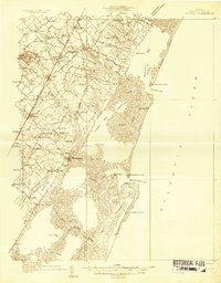
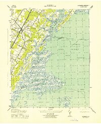
1941 Map of Broadwater
USGS Topo · Published 1941About this map
Hog Island dominates this maritime landscape along the Virginia coast, serving as the site for the settlement of Broadwater. This survey by the U. S. Coast and Geodetic Survey reveals a complex network of coastal waterways and shifting sands during the early 1940s. The entire area is noted as being less than 20 feet above mean sea level, emphasizing the fragile nature of these barrier islands. A significant Cable Area and the Little Machipongo Inlet C G S station highlight the strategic and navigational importance of this stretch of the Atlantic Ocean. Numerous navigable paths such as Sloop Channel, Cutter Channel, and Heather Channel wind through the marshy interior behind the islands, providing vital passages between the open sea and the mainland of Accomac County and Northampton County.
Find a feature on this map
24 named features on this map. Tap any name to fly to it.
Don’t see what you’re looking for? This feature index may not catch every label — zoom into the map to look around manually.
Map Details
Editions of this 1941 Broadwater Map
This is the sole edition of this map. No revisions or reprints were ever made.
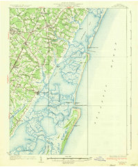
Other maps of this area
1931 · Accomac
USGS Topo · 1:48,000
1935 · Accomac
USGS Topo · 1:62,500

1942 · Cobb Island
USGS Topo · 1:24,000
1942 · Great Machipongo Inlet
USGS Topo · 1:24,000

1942 · Little Machipongo Inlet
USGS Topo · 1:24,000
1942 · Nassawadox
USGS Topo · 1:24,000
1943 · Nassawadox
USGS Topo · 1:31,680
1943 · Exmore
USGS Topo · 1:24,000
1944 · Exmore
USGS Topo · 1:31,680

1946 · Eastville
USGS Topo · 1:250,000