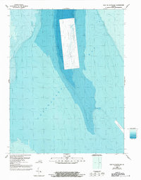
1986 Map of East of Fleets Bay
USGS Topo · Published 1992About this map
Chesapeake Bay waters dominate this bathymetric study, revealing the underwater topography of the Virginia coastline during the mid-1980s. The survey focuses heavily on the submerged landscape, characterized by a complex network of depth gradients and a prominent shipping Channel. A significant human-engineered feature is the large, rectangular Disposal Area situated in the central portion of the bay, where sediment from dredging operations was historically relocated. This map, compiled by the National Ocean Service and revised in the early 1990s, serves as a record of the maritime infrastructure and underwater contours required for safely managing the bay's busy shipping lanes and environmental management zones.
Find a feature on this map
3 named features on this map. Tap any name to fly to it.
Don’t see what you’re looking for? This feature index may not catch every label — zoom into the map to look around manually.
Map Details
Editions of this 1986 East of Fleets Bay Map
2 editions found
Other maps of this area

1916 · Kilmarnock
USGS Topo · 1:48,000

1917 · Heathsville
USGS Topo · 1:48,000

1917 · Kilmarnock
USGS Topo · 1:62,500

1917 · Ewell
USGS Topo · 1:62,500

1942 · Kilmarnock
USGS Topo · 1:62,500

1943 · Richmond
USGS Topo · 1:250,000

1944 · Reedville
USGS Topo · 1:31,680

1948 · Deltaville
USGS Topo · 1:24,000
1949 · Fleets Bay
USGS Topo · 1:24,000

1949 · Richmond
USGS Topo · 1:250,000