1942 Map of Kilmarnock
USGS Topo · Published 1942About this map
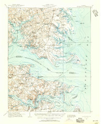
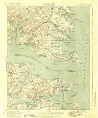
Steamboat routes crisscross the Rappahannock River and Fleets Bay in this coastal survey, where the water-driven economy of the Northern Neck and Middle Peninsula is at its peak. The landscape is defined by its deep reliance on river transport, anchored by numerous maritime hubs like Kilmarnock Wharf, Whitestone Wharf, and Jackson Creek Wharf. Inland, the map reveals a network of rural community centers, including Kilmarnock and Deltaville, alongside historically significant structures such as Christ Church and Old Brick Church.
Find a feature on this map
152 named features on this map. Tap any name to fly to it.
Don’t see what you’re looking for? This feature index may not catch every label — zoom into the map to look around manually.
Map Details
Editions of this 1942 Kilmarnock Map
This is the sole edition of this map. No revisions or reprints were ever made.
Historical Maps of Kilmarnock Through Time
3 maps found