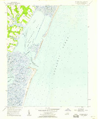
1957 Map of Metomkin Inlet
USGS Topo · Published 1958About this map
The Atlantic coast of Accomack County is defined here by a complex network of barrier islands, tidal guts, and shallow bays. Along the western edge, fingers of land including Parker Neck, Baylys Neck, and Joynes Neck extend into the marshes, separated by tidal waters like Parker Creek and Walston Creek. These necks show sparse development, marked only by scattered structures and a few small cemeteries.
Find a feature on this map
40 named features on this map. Tap any name to fly to it.
Don’t see what you’re looking for? This feature index may not catch every label — zoom into the map to look around manually.
Map Details
Editions of this 1957 Metomkin Inlet Map
This is the sole edition of this map. No revisions or reprints were ever made.
Other maps of this area

1931 · Accomac
USGS Topo · 1:48,000

1935 · Accomac
USGS Topo · 1:62,500

1942 · Mappsville
USGS Topo · 1:24,000

1942 · Wallops Island
USGS Topo · 1:24,000

1942 · Parksley
USGS Topo · 1:24,000

1943 · Parksley
USGS Topo · 1:31,680

1943 · Mappsville
USGS Topo · 1:31,680

1943 · Wallops Island
USGS Topo · 1:31,680

1946 · Eastville
USGS Topo · 1:250,000
1957 · Accomac
USGS Topo · 1:24,000