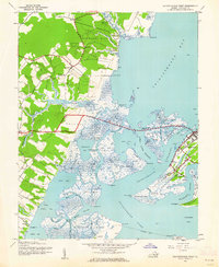
1943 Map of Chincoteague West
USGS Topo · Published 1962About this map
Chincoteague sits at the heart of this complex coastal landscape, separated from the mainland by a network of tidal thoroughfares and marshes. The map documents the intricate waterways of the Eastern Shore during the early 1940s, showing the early footprints of Wallops Island and Assateague Island before the height of modern development. Small communities like Sinnickson, Horntown, and Wattsville are linked by rural roads and local landmarks such as Signpost Ch and Dees Chapel.
Find a feature on this map
71 named features on this map. Tap any name to fly to it.
Don’t see what you’re looking for? This feature index may not catch every label — zoom into the map to look around manually.
Map Details
Editions of this 1943 Chincoteague West Map
2 editions found
Other maps of this area

1901 · Snow Hill
USGS Topo · 1:62,500

1942 · Chincoteague East
USGS Topo · 1:24,000

1942 · Mappsville
USGS Topo · 1:24,000

1942 · Wallops Island
USGS Topo · 1:24,000

1943 · Boxiron
USGS Topo · 1:31,680

1943 · Mappsville
USGS Topo · 1:31,680

1943 · Chincoteague West
USGS Topo · 1:31,680
1943 · Girdletree
USGS Topo · 1:31,680
1943 · Hallwood
USGS Topo · 1:31,680
1943 · Pocomoke City
USGS Topo · 1:31,680