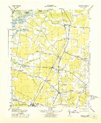
1943 Map of Hallwood
USGS Topo · Published 1943About this map
Pennsylvania railroad tracks bisect this portion of the Delmarva Peninsula, connecting a string of rural stations and crossroads during the Second World War. The landscape is defined by its transition from the tidal waters of the Pocomoke River and Messongo Creek to the inland agricultural communities of Hallwood and Temperanceville. Local commerce and community life center on small clusters like Jenkins Bridge, where the post office and nearby Tunnels Mill reflect an economy tied to both land and water. Numerous spiritual landmarks, including Jerusalem Ch and Shilo Ch, are scattered across the terrain, serving the established families of Atlantic and New Church. The map provides a precise record of the road network and property distribution just as the region’s traditional coastal and rail-dependent industries were shifting toward modern transit.
Find a feature on this map
46 named features on this map. Tap any name to fly to it.
Don’t see what you’re looking for? This feature index may not catch every label — zoom into the map to look around manually.
Map Details
Editions of this 1943 Hallwood Map
This is the sole edition of this map. No revisions or reprints were ever made.
Other maps of this area

1901 · Snow Hill
USGS Topo · 1:62,500

1942 · Kingston
USGS Topo · 1:24,000

1942 · Mappsville
USGS Topo · 1:24,000

1942 · Wallops Island
USGS Topo · 1:24,000

1942 · Saxis
USGS Topo · 1:24,000

1942 · Parksley
USGS Topo · 1:24,000

1943 · Parksley
USGS Topo · 1:31,680

1943 · Saxis
USGS Topo · 1:31,680

1943 · Mappsville
USGS Topo · 1:31,680

1943 · Chincoteague West
USGS Topo · 1:31,680