Old Maps of Chincoteague, Virginia
Explore 51 old maps of Chincoteague, spanning from 1901 to today. These high-resolution historic maps reveal how streets, neighborhoods, landmarks, and natural features evolved over time — perfect for genealogy, metal detecting, research, and local history exploration.
What you can do with these maps:
- See how Chincoteague changed over time: Compare historical maps to modern-day views to trace roads, homesites, rail lines & more.
- View detailed metadata: Each map includes creators, publishers, year, scale, and archive source.
- Overlay maps with satellite & LiDAR: Visualize the past alongside modern tools to explore terrain & human change.
- Trusted historical sources: Maps sourced from the USGS, Library of Congress, and other archives.
- Access maps your way: View online, download high-res files, or order prints for personal or research use.
Start exploring old maps of Chincoteague to uncover forgotten places, hidden landmarks, and the deep history beneath your feet.
Chincoteague, VA maps
(51)- 1901 Map of Snow Hill
 1901 Snow Hill1901 Print · USGSSnow Hill and the surrounding Worcester County wetlands are captured at the opening of the twentieth century, when the Pocomoke River was a vital Steamboat Route. Researchers can trace the Waterman culture through historic sites like Public Landing and the railway hubs at Girdletree and Stockton.4 unique versions available
 - 1942 Map of Chincoteague East, 1962 Print
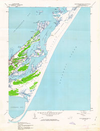 1942 Chincoteague East1962 Print · USGSCoastal Virginia in the early 1940s is shown here as a landscape of interconnected bays and marshes. Researchers can locate the Assateague Lighthouse, the military footprint at Camp Fletcher, and the small community at Birch Town.
 - 1942 Map of Wallops Island, 1962 Print
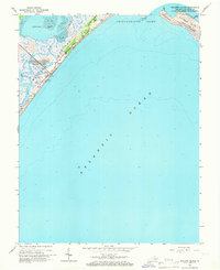
 1942 Wallops Island1962 Print · USGSWallops Island and the Accomack coast are captured here during the early years of the war, when this barrier beach was defined by maritime watchmen rather than rockets. Researchers can trace the original location of the Wallops Beach Coast Guard Station and the lone Watch House among the marshes of Bogues Bay.
 - 1943 Map of Boxiron
 1943 Boxiron1943 Print · USGSThe Maryland-Virginia borderlands are captured here during the mid-century, showing a landscape of tidal marshes and remote coastal landings. Researchers can trace historic access points like George Island Landing and family-named features such as Robbins Tump or Purnell Pond.
 - 1943 Map of Chincoteague West
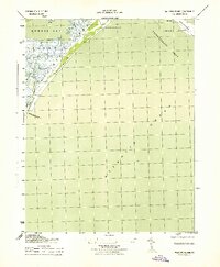
 1943 Chincoteague West1943 Print · USGSThe Virginia coast during the Second World War reveals a landscape of isolated marsh settlements and maritime landmarks. Genealogists and historians can trace family roots around Signpost Church, Horntown, and the early infrastructure of Wallops Island.2 unique versions available
 - 1943 Map of Wallops Island
 1943 Wallops Island1943 Print · USGSThe Virginia barrier islands appear here during the Second World War, showing a sparsely developed coastal landscape. Maritime researchers can trace the old shoreline via the Wallops Beach Coast Guard Station, Watch House, and Assawaman Inlet.
 - 1943 Map of Chincoteague East
 1943 Chincoteague East1943 Print · USGSAccomack County's coastal landscape appears during the wartime years, showing the traditional island communities of the Virginia shore. Researchers can trace the layout of Chincoteague and Birch Town or locate landmarks like the Assateague Lighthouse.
 - 1946 Map of Salisbury, 1948 Print
 1946 Salisbury1948 Print · USGSThe Delmarva Peninsula in the late nineteen-forties shows a landscape defined by its deep river arteries and emerging coastal defenses. Genealogists and historians can trace rail-connected towns like Federalsburg or locate maritime landmarks such as the Ocean City Seaplane Base and Fort Miles Military Reservation.4 unique versions available
 - 1946 Map of Eastville, 1971 Print
 1946 Eastville1971 Print · USGSCoastal Virginia and the Outer Banks are captured here during a period of expanding naval and aerospace presence. Researchers can trace the path of the Penn Central railroad through Chincoteague and Modest Town, or locate landmarks like the Wright Brothers National Memorial.
 - 1947 Map of Salisbury, 1948 Print
 1947 Salisbury1948 Print · USGSThe Delmarva Peninsula in the late forties reveals a coastal landscape of maritime defense and growing seaside towns. Trace the post-war footprint of Salisbury, the strategic Fort Miles Military Reservation, and the Ocean City Seaplane Base.
 - 1948 Map of Salisbury, 1951 Print
 1948 Salisbury1951 Print · USGSThe Delmarva Peninsula in the late 1940s is shown here as a busy network of rail-towns and coastal outposts. Researchers can trace the legacy of the Pennsylvania Railroad through inland hubs like Georgetown or the maritime reaches of Crisfield and Cape May.
 - 1953 Map of Boxiron
 1953 Boxiron1953 Print · USGSCoastal Maryland and Virginia at mid-century reveal a landscape of tidal marshes and remote landings along the Chincoteague Bay. Genealogists and historians can trace old shoreline access points like Truitt Landing and Scarboro Landing near Boxiron.
 - 1957 Map of Salisbury
 1957 Salisbury1957 Print · USGSThe Delmarva Peninsula in the mid-1950s reveals a landscape of coastal defenses and rail-driven commerce. Researchers can trace the Pennsylvania railroad lines or locate historic landmarks like the Fenwick Island Lighthouse and St Martin church.
 - 1961 Map of Eastville
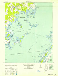
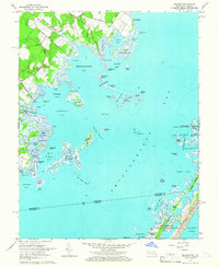
 1961 Eastville1961 Print · USGSThe Eastern Shore and Outer Banks are captured here in the mid-twentieth century, showing a maritime landscape of lighthouses, rail-linked towns, and naval outposts. Researchers can trace the Pennsylvania Railroad through Parksley or locate historical sites like Chincoteague Field Naval Auxiliary Air Station and Tangier Island.
 - 1961 Map of Salisbury
 1961 Salisbury1961 Print · USGSThe Delmarva Peninsula comes into focus in the early sixties, showing the vital road and rail networks connecting the Chesapeake to the Atlantic. Genealogists and historians can trace family-named landings and coastal landmarks from Crisfield to the Brandywine Shoal Lighthouse.
 - 1964 Map of Boxiron, 1966 Print
 1964 Boxiron1966 Print · USGSThe Worcester County coast during the mid-sixties reveals a landscape of isolated landings and intricate tidal waterways. Genealogists and historians can trace family-named sites like Scarboro Landing, the settlement of Boxiron, and landmarks such as Tizzard Island.3 unique versions available
 - 1965 Map of Chincoteague West
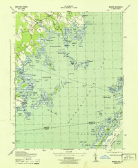
 1965 Chincoteague West1965 Print · USGSCoastal Accomack County underwent a significant transformation in the mid-sixties as NASA operations and national seashores expanded. Genealogists and local historians can trace the streets of Chincoteague or locate rural landmarks like Horntown and the Tabernacle Ch.5 unique versions available
 - 1965 Map of Salisbury
 1965 Salisbury1965 Print · USGSThe Delmarva Peninsula in the mid-1960s is depicted here as a landscape of coastal defenses and maritime hubs. Genealogists and local historians can trace the foundations of bayside towns like Crisfield and the tactical positioning of the Fort Miles Military Reservation and Cape May Naval Air Station.
 - 1965 Map of Wallops Island, 1966 Print
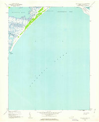
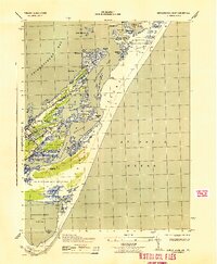
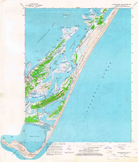
 1965 Wallops Island1966 Print · USGSThe Virginia coastline in the mid-sixties reveals the early technological footprint of the space race amidst the marshes of the Eastern Shore. Researchers can trace the layout of early Launch Pads on Wallops Island and the pristine reaches of Toms Cove.5 unique versions available
 - 1965 Map of Chincoteague East, 1966 Print
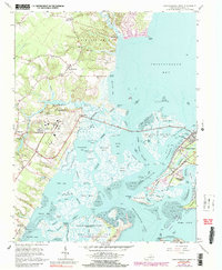
 1965 Chincoteague East1966 Print · USGSThe Virginia coastline comes to life in the mid-1960s, showing the intricate barrier islands and fishing communities of the Eastern Shore. Researchers can trace the streets of Chincoteague, locate family plots at Ridge Cem, or find the Assateague Beach U S Coast Guard Station.4 unique versions available
 - 1966 Map of Eastville
 1966 Eastville1966 Print · USGSThe Delmarva Peninsula and Outer Banks appear in the mid-sixties, showing a landscape of maritime trade, military outposts, and fishing villages. Researchers can trace the lines of the Norfolk & Southern through Exmore and Parksley or locate historical sites like Fort John Custis and the Janes Island Lighthouse.
 - 1978 Map of Chincoteague East, 1983 Print
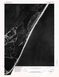 1978 Chincoteague East1983 Print · USGSAssateague Island and the Virginia coastline are captured in high-detail aerial photography during the late seventies. Researchers can trace the shifting sands of the barrier beach and study the intricate tidal marshes surrounding Chincoteague Bay and Toms Cove.
 - 1981 Map of Chincoteague, 1982 Print
 1981 Chincoteague1982 Print · USGSThe Delmarva Eastern Shore at the start of the eighties shows a unique blend of traditional coastal life and modern aerospace technology. Researchers can trace the Penn Central rail line through rural towns like Modest Town and Bloxom or explore the marshlands of the Saxis Marsh Waterfowl Management Area and Refuge.
 - 1983 Map of Salisbury, 1984 Print
 1983 Salisbury1984 Print · USGSThe Lower Eastern Shore was a landscape of tide and timber in the early eighties, from the bustling streets of Salisbury to the wild coast of Assateague Island. Researchers can trace the rail-and-road network of the Conrail and U S Highway 50 while locating historic centers like Princess Anne and Crisfield.
 - 1984 Map of Chincoteague
 1984 Chincoteague1984 Print · USGSThe Virginia Eastern Shore and Delmarva Peninsula are captured here in the mid-1980s, showcasing a landscape of barrier islands and tidewater towns. Researchers can trace the Penn Central rail line through Accomac or locate the Wallops Flight Facility (NASA) and Chincoteague Nat Wildlife Refuge.2 unique versions available
Showing maps 1-25 of 51
Top cities near Chincoteague
- Pocomoke City historical maps
- Snow Hill historical maps
- Captains Cove historical maps
- Wattsville historical maps
- Horntown historical maps
- Atlantic historical maps
See more
Top neighborhoods of Chincoteague
Frequently asked questions
- What are the different types of historical maps available for Chincoteague?
- What is the oldest map of Chincoteague?
- Where can I purchase historical maps of Chincoteague for my home or office?
- Where can I download high-res historical maps of Chincoteague?
- Are there historical topographic maps available for Chincoteague?
- Is there historical aerial imagery available for Chincoteague?
- Where are historical maps of Chincoteague sourced from?