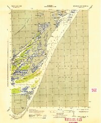
1943 Map of Chincoteague East
USGS Topo · Published 1943About this map
Chincoteague island life in the early 1940s is defined by its intricate relationship with the surrounding marshlands and the Atlantic coast. This War Department survey reveals the concentrated settlement at Chincoteague and the smaller Birch Town, providing a clear view of the local landscape before modern development. Notable landmarks such as the Assateague Lighthouse and the Assateague C G station underscore the area's maritime importance, while the presence of Camp Fletcher reflects the era's military activity.
Find a feature on this map
52 named features on this map. Tap any name to fly to it.
Don’t see what you’re looking for? This feature index may not catch every label — zoom into the map to look around manually.
Map Details
Editions of this 1943 Chincoteague East Map
This is the sole edition of this map. No revisions or reprints were ever made.
Other maps of this area

1901 · Snow Hill
USGS Topo · 1:62,500

1901 · Green Run
USGS Topo · 1:62,500

1938 · Green Run
USGS Topo · 1:62,500

1942 · Chincoteague East
USGS Topo · 1:24,000

1942 · Wallops Island
USGS Topo · 1:24,000

1943 · Boxiron
USGS Topo · 1:31,680

1943 · Whittington Point
USGS Topo · 1:31,680

1943 · Chincoteague West
USGS Topo · 1:31,680
1943 · Girdletree
USGS Topo · 1:31,680

1943 · Wallops Island
USGS Topo · 1:31,680