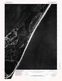
1978 Map of Chincoteague East
USGS Topo · Published 1983About this map
Chincoteague Bay dominates this late-1970s orthophotograph, illustrating the complex barrier island system of the Virginia coast. Prepared by the Geological Survey and the Soil Conservation Service, this imagery captures the intricate network of salt marshes, tidal guts, and the narrow barrier beach that shields the inland waters from the Atlantic Ocean. The photographic format reveals the actual density of maritime forest and marsh vegetation, providing a more literal view of the landscape than a traditional line-drawn map. Waterways like the Chincoteague Channel and Toms Cove are shown in high contrast against the surrounding landforms, documenting the natural state of these dynamic coastal features as they appeared in 1978.
Find a feature on this map
4 named features on this map. Tap any name to fly to it.
Don’t see what you’re looking for? This feature index may not catch every label — zoom into the map to look around manually.
Map Details
Editions of this 1978 Chincoteague East Map
This is the sole edition of this map. No revisions or reprints were ever made.
Other maps of this area

1901 · Snow Hill
USGS Topo · 1:62,500

1901 · Green Run
USGS Topo · 1:62,500

1938 · Green Run
USGS Topo · 1:62,500

1942 · Chincoteague East
USGS Topo · 1:24,000

1942 · Wallops Island
USGS Topo · 1:24,000

1943 · Boxiron
USGS Topo · 1:31,680

1943 · Whittington Point
USGS Topo · 1:31,680

1943 · Chincoteague West
USGS Topo · 1:31,680
1943 · Girdletree
USGS Topo · 1:31,680

1943 · Wallops Island
USGS Topo · 1:31,680