1960s Maps of Rivanna, Virginia
Explore 5 historic maps of Rivanna from the 1960s. These maps offer a rare glimpse into what life looked like during the 1960s — showing old roads, neighborhoods, homes, and landmarks that have changed or disappeared over time.
Whether you're researching your family's past, planning a metal detecting trip, or studying how Rivanna's landscape evolved across the 1960s, these high-resolution maps are a powerful tool for exploring the history of this region.
- Focus on a specific era: All maps on this page are from the 1960s, giving you a focused view of this time period.
- See what’s changed: Compare century-old streets, trails, and buildings to today's modern landscape using overlays and satellite layers.
- Research with precision: Use these maps for genealogy, historical research, land use analysis, or educational projects.
- View, download, or print: Maps are fully viewable online in high resolution, and can be downloaded or printed for your own records.
Start exploring Rivanna's history through authentic maps from the 1960s. This is your window into the past.
Rivanna, VA maps
(5)- 1963 Map of Roanoke
 1963 Roanoke1963 Print · USGSCentral Virginia and the Blue Ridge front appear here in the early sixties, caught between their deep railroad roots and new postwar developments. Genealogists and historians can trace the rail lines of the Norfolk and Western through towns like Bedford and Altavista, or locate family landmarks near Smith Mountain Lake.
 - 1964 Map of Charlottesville East, 1965 Print
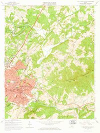 1964 Charlottesville East1965 Print · USGSCharlottesville and the surrounding Albemarle hills are captured here in the mid-sixties, just as the local landscape was being reshaped by new infrastructure. Genealogists and historians can locate Monticello, trace the vanished streets of Vinegar Hill, or find family names at Michie Tavern Cem and Griffin Cem.2 unique versions available
 - 1964 Map of Keswick, 1965 Print
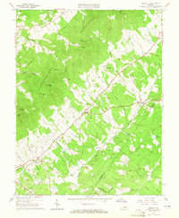 1964 Keswick1965 Print · USGSAlbemarle County's rural landscape is captured here in the mid-1960s, defined by the rise of the Southwestern Mountains and the busy Chesapeake and Ohio railroad. Researchers can trace family sites and old roads near Walkers Parish Ch, Cismont, and the Shackelford Cem.5 unique versions available
 - 1967 Map of Boyd Tavern, 1968 Print
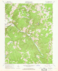 1967 Boyd Tavern1968 Print · USGSFluvanna County's rural landscape is captured here in the late sixties as the Rivanna River snakes through a region of old mills and crossroads. Genealogists can trace family footprints near historic sites like Boyd Tavern, Union Mills, and Haden Chapel.4 unique versions available
 - 1967 Map of Simeon, 1969 Print
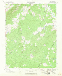 1967 Simeon1969 Print · USGSAlbemarle County is shown in the mid-sixties, capturing the rural character of the Piedmont hills before modern suburban expansion. Genealogists and historians can trace the estates at Ash Lawn and Blenheim alongside local landmarks like Middle Oak Ch.2 unique versions available
End of results
Showing maps 1-5 of 5
Top cities near Rivanna
- Charlottesville historical maps
- Lake Monticello historical maps
- Hollymead historical maps
- University of Virginia historical maps
- Pantops historical maps
- Rio historical maps
See more
Frequently asked questions
- What are the different types of historical maps available for Rivanna?
- What is the oldest map of Rivanna?
- Where can I purchase historical maps of Rivanna for my home or office?
- Where can I download high-res historical maps of Rivanna?
- Are there historical topographic maps available for Rivanna?
- Is there historical aerial imagery available for Rivanna?
- Where are historical maps of Rivanna sourced from?