1990s Maps of Alleghany County, Virginia
Explore 4 historic maps of Alleghany County from the 1990s. These maps offer a rare glimpse into what life looked like during the 1990s — showing old roads, neighborhoods, homes, and landmarks that have changed or disappeared over time.
Whether you're researching your family's past, planning a metal detecting trip, or studying how Alleghany County's landscape evolved across the 1990s, these high-resolution maps are a powerful tool for exploring the history of this region.
- Focus on a specific era: All maps on this page are from the 1990s, giving you a focused view of this time period.
- See what’s changed: Compare century-old streets, trails, and buildings to today's modern landscape using overlays and satellite layers.
- Research with precision: Use these maps for genealogy, historical research, land use analysis, or educational projects.
- View, download, or print: Maps are fully viewable online in high resolution, and can be downloaded or printed for your own records.
Start exploring Alleghany County's history through authentic maps from the 1990s. This is your window into the past.
Alleghany County, VA maps
(4)- 1995 Map of Alvon, 1998 Print
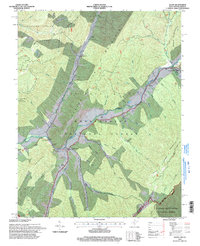 1995 Alvon1998 Print · USGSGreenbrier County, West Virginia, is shown in the mid-1990s as a forested mountain landscape where the state border meets two national forests. Researchers can trace rural life and industry through labels for Neola, Anthony Creek Sch, and the Anthony Correctional Center.
 - 1995 Map of Rucker Gap, 1998 Print
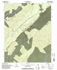 1995 Rucker Gap1998 Print · USGSThe high ridges of the Virginia-West Virginia border are captured here in the mid-1990s, where national forests meet at the crest of Allegheny Mountain. Trace local heritage through landmarks like Watts Chapel Cem and the mineral springs at Columbia Sulphur Springs.
 - 1995 Map of White Sulphur Springs, 1998 Print
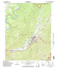 1995 White Sulphur Springs1998 Print · USGSThe Greenbrier Valley in the mid-1990s showcases a balance of mountain forest and resort-town development. Genealogists and historians can trace family-named landmarks and rural outposts like Mapledale, Eckle Ch, and the high ridges of Coles Mountain.
 - 1995 Map of Jerrys Run, 1998 Print
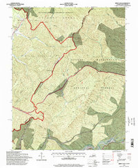 1995 Jerrys Run1998 Print · USGSThe Virginia and West Virginia borderlands in the mid-nineties reveal a landscape of mountain engineering and national forest tracts. Researchers can trace the path of numerous rail and utility tunnels like Lewis Tunnels and Moores Tunnel near Alleghany.
End of results
Showing maps 1-4 of 4
Top cities of Alleghany County
- Clifton Forge historical maps
- Mallow historical maps
- Low Moor historical maps
- Iron Gate historical maps
- Selma historical maps
- Cliftondale Park historical maps
See more
Frequently asked questions
- What are the different types of historical maps available for Alleghany County?
- What is the oldest map of Alleghany County?
- Where can I purchase historical maps of Alleghany County for my home or office?
- Where can I download high-res historical maps of Alleghany County?
- Are there historical topographic maps available for Alleghany County?
- Is there historical aerial imagery available for Alleghany County?
- Where are historical maps of Alleghany County sourced from?