1940s Maps of Intervale, Virginia
Explore 3 historic maps of Intervale from the 1940s. These maps offer a rare glimpse into what life looked like during the 1940s — showing old roads, neighborhoods, homes, and landmarks that have changed or disappeared over time.
Whether you're researching your family's past, planning a metal detecting trip, or studying how Intervale's landscape evolved across the 1940s, these high-resolution maps are a powerful tool for exploring the history of this region.
- Focus on a specific era: All maps on this page are from the 1940s, giving you a focused view of this time period.
- See what’s changed: Compare century-old streets, trails, and buildings to today's modern landscape using overlays and satellite layers.
- Research with precision: Use these maps for genealogy, historical research, land use analysis, or educational projects.
- View, download, or print: Maps are fully viewable online in high resolution, and can be downloaded or printed for your own records.
Start exploring Intervale's history through authentic maps from the 1940s. This is your window into the past.
Intervale, VA maps
(3)- 1945 Map of Clifton Forge, 1963 Print
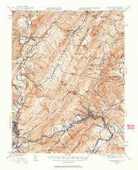 1945 Clifton Forge1963 Print · USGSThe rail and river corridors of Alleghany County are captured here at the end of the war, centered on the bustling junction of Clifton Forge. Genealogists and historians can trace old community landmarks like Union Chapel, the Rich Patch Mines, and the Deeds Sch among the ridgelines.2 unique versions available
 - 1947 Map of Roanoke, 1948 Print
 1947 Roanoke1948 Print · USGSCentral Virginia in the late 1940s reveals a region defined by its great mountain ridges and the powerful river-and-rail economy connecting Roanoke to Lynchburg. Researchers can trace the path of the Virginian RR and locate historic county seats like Charlotte Court House.2 unique versions available
 - 1949 Map of Clifton Forge
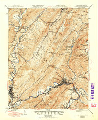 1949 Clifton Forge1949 Print · USGSThe industrial corridor of the Alleghany Highlands thrives in the late 1940s as rail and river networks converge. Researchers can trace historic family-named landmarks and mountain settlements like Carloover, Rich Patch Mines, and Union Chapel.3 unique versions available
End of results
Showing maps 1-3 of 3
Top cities near Intervale
- Covington historical maps
- Clifton Forge historical maps
- Mallow historical maps
- Hot Springs historical maps
- Low Moor historical maps
- Iron Gate historical maps
See more
Frequently asked questions
- What are the different types of historical maps available for Intervale?
- What is the oldest map of Intervale?
- Where can I purchase historical maps of Intervale for my home or office?
- Where can I download high-res historical maps of Intervale?
- Are there historical topographic maps available for Intervale?
- Is there historical aerial imagery available for Intervale?
- Where are historical maps of Intervale sourced from?