
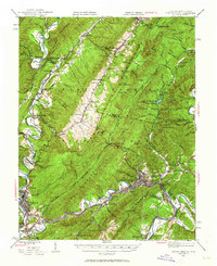
1945 Map of Clifton Forge
USGS Topo · Published 1963About this map
Clifton Forge sits as a vital rail and industrial hub at the convergence of the Jackson River and the Chesapeake and Ohio RR, dominating the valley landscape between Warm Springs Mountain and Rich Patch Mountain. The map reveals a mid-century infrastructure supporting both industry and recreation, from the Rich Patch Mines in the south to the developed leisure spaces of Douthat State Park and the Cascades Golf Club. The transportation network is defined by the steep river gaps, particularly where the railroad and river navigate The Gorge.
Find a feature on this map
115 named features on this map. Tap any name to fly to it.
Don’t see what you’re looking for? This feature index may not catch every label — zoom into the map to look around manually.
Map Details
Editions of this 1945 Clifton Forge Map
2 editions found
Other maps of this area

1887 · Lewisburg
USGS Topo · 1:125,000

1891 · Lewisburg
USGS Topo · 1:125,000

1891 · Huntersville
USGS Topo · 1:125,000

1894 · Huntersville
USGS Topo · 1:125,000

1894 · Natural Bridge
USGS Topo · 1:125,000

1894 · Natural Bridge
USGS Topo · 1:62,500

1901 · Monterey
USGS Topo · 1:125,000

1907 · Natural Bridge Special
USGS Topo · 1:62,500

1913 · Eagle Rock
USGS Topo · 1:48,000

1915 · Eagle Rock
USGS Topo · 1:62,500