
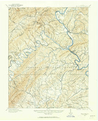
1913 Map of Eagle Rock
USGS Topo · Published 1913About this map
Fincastle serves as the focal point for this survey of the Botetourt County landscape, just before the First World War. The map details a period when rural life centered around small river-crossing settlements and a dense network of local schools and churches. Evidence of early industrial and agricultural activity is visible at Salisbury Furnace and the Fair Grounds south of the county seat. The James River and Craig Creek dominate the topography, providing the routes for transportation and commerce.
Find a feature on this map
50 named features on this map. Tap any name to fly to it.
Don’t see what you’re looking for? This feature index may not catch every label — zoom into the map to look around manually.
Map Details
Editions of this 1913 Eagle Rock Map
2 editions found
Other maps of this area

1887 · Lewisburg
USGS Topo · 1:125,000

1890 · Roanoke
USGS Topo · 1:125,000

1890 · Christiansburg
USGS Topo · 1:125,000

1891 · Roanoke
USGS Topo · 1:125,000

1891 · Lewisburg
USGS Topo · 1:125,000

1894 · Natural Bridge
USGS Topo · 1:125,000

1894 · Natural Bridge
USGS Topo · 1:62,500

1907 · Natural Bridge Special
USGS Topo · 1:62,500

1915 · Eagle Rock
USGS Topo · 1:62,500

1921 · Callaghan
USGS Topo · 1:48,000