1900s (20th Century) Maps of Augusta County, Virginia
Explore 83 historic maps of Augusta County from the 1900s (20th Century). These maps offer a rare glimpse into what life looked like during the 1900s — showing old roads, neighborhoods, homes, and landmarks that have changed or disappeared over time.
Whether you're researching your family's past, planning a metal detecting trip, or studying how Augusta County's landscape evolved across the 1900s, these high-resolution maps are a powerful tool for exploring the history of this region.
- Focus on a specific era: All maps on this page are from the 1900s, giving you a focused view of this time period.
- See what’s changed: Compare century-old streets, trails, and buildings to today's modern landscape using overlays and satellite layers.
- Research with precision: Use these maps for genealogy, historical research, land use analysis, or educational projects.
- View, download, or print: Maps are fully viewable online in high resolution, and can be downloaded or printed for your own records.
Start exploring Augusta County's history through authentic maps from the 1900s. This is your window into the past.
Augusta County, VA maps
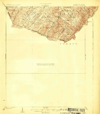
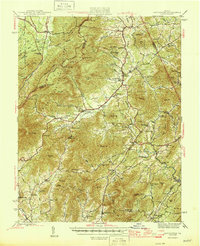
(83)- 1901 Map of Monterey, 1905 Print
 1901 Monterey1905 Print · USGSThe high Allegheny ridges of Highland and Bath Counties are shown at the turn of the century when isolated valley settlements were linked by winding mountain gaps. Genealogists can trace early homesteads and commerce centers like Cleeks Mills, Mountaingrove, and New Hampden.8 unique versions available
 - 1924 Map of Mc Dowell
 1924 Mc Dowell1924 Print · USGSHighland County and the Allegheny borderlands are shown in the early twenties, a time of isolated mountain communities and high-ridge forests. Genealogists can trace family footprints at St Paul Church, Mt Hull School, and the remote Crummet Church.5 unique versions available
 - 1931 Map of University
 1931 University1931 Print · USGSAlbemarle County is shown here during the late Prohibition era, when the university and the railroad defined the local economy. Genealogists can trace family names through landmarks like the Miller School, Whitehall, and Mt Plains Ch.2 unique versions available
 - 1932 Map of Lexington
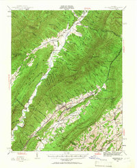
 1932 Lexington1932 Print · USGSRockbridge County in the early 1930s shows a landscape of academic centers and rural mill towns. Genealogists and historians can trace family locations near Rockbridge Alum Springs, Brownsburg Mill, or the segregated White Hall (Colored View) School.
 - 1934 Map of Waynesboro
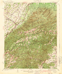
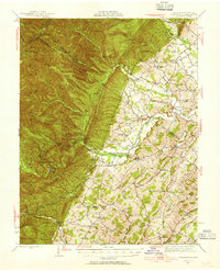
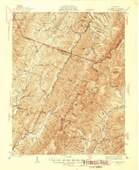
 1934 Waynesboro1934 Print · USGSAugusta County settlements and Blue Ridge rail lines are captured here in the mid-1930s as the regional economy modernized. Local historians can trace old schools and churches from Fort Defiance to Lipscomb, including Old Stone Ch and the Blue Ridge Tunnel.2 unique versions available
 - 1935 Map of University, 1962 Print
 1935 University1962 Print · USGSAlbemarle County is captured here in the mid-thirties as the new national park and Skyline Drive begin to reshape the Blue Ridge peaks. Genealogists can trace family names across dozens of rural institutions, from the Miller School to Meriwether Lewis Sch and Hillsboro.
 - 1936 Map of Vesuvius
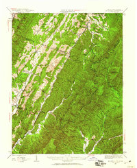
 1936 Vesuvius1936 Print · USGSThe Blue Ridge mountain front meets the Shenandoah Valley in the 1930s, showing a land of rail junctions and high-country mines. Researchers can trace the Appalachian Trail past peaks like The Priest and find local history at Steeles Tavern or Old Providence Cem.
 - 1937 Map of Lexington
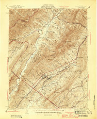
 1937 Lexington1937 Print · USGSRockbridge County during the mid-1930s shows a landscape defined by mountain gaps and the river-and-rail economy of the Shenandoah Valley. Researchers can trace old family names and rural infrastructure through Rockbridge Baths, McClung Mill, and New Monmouth Ch.3 unique versions available
 - 1939 Map of Waynesboro
 1939 Waynesboro1939 Print · USGSThe Shenandoah Valley meets the Blue Ridge in the late 1930s, showing a critical crossroads of rail and mountain passage. Genealogists can trace family names and institutions from the Augusta Military Academy at Fort Defiance to the Blue Ridge Tunnel near Waynesboro.3 unique versions available
 - 1941 Map of Vesuvius
 1941 Vesuvius1941 Print · USGSThe Blue Ridge highlands at the start of the 1940s reveal a landscape of mountain mines and early parkway development. Genealogists and hikers can trace the Appalachian Trail past the Irish Creek Mission and forgotten sites like Mill Creek Sch.2 unique versions available
 - 1941 Map of Harrisonburg, 1965 Print
 1941 Harrisonburg1965 Print · USGSHarrisonburg and the surrounding Rockingham County countryside are shown here in the early 1940s, a landscape shaped by rail, river, and regional history. Genealogists can trace family roots through landmarks like Weyers Cave, St Michaels Ch, and the Civilian Public Service Camp No 8.
 - 1943 Map of Harrisonburg
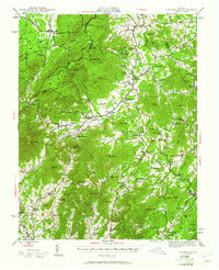
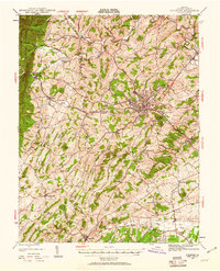
 1943 Harrisonburg1943 Print · USGSMid-century Rockingham County centers on the growing college town of Harrisonburg as the surrounding valley thrives on a mix of agriculture and rail commerce. Genealogists can trace family names through dozens of rural landmarks like Weyers Cave, Bridgewater College, and Melanchthon Chapel.
 - 1943 Map of Craigsville, 1961 Print
 1943 Craigsville1961 Print · USGSThe Virginia mountains in the early 1940s reveal a landscape of rail-dependent valley towns and isolated mountain gaps. You can trace family roots through rural landmarks like Griffin Ch, the Wilderness Sch, and the high peak at Elliott Knob.
 - 1943 Map of Lovingston, 1961 Print
 1943 Lovingston1961 Print · USGSThe Nelson County foothills and Blue Ridge summits are captured in the early 1940s, during a transitional period for Virginia's upland communities. Genealogists and historians can trace family locations near Lovingston or find rural landmarks like Locust Grove Ch, Woods Mill, and the Stage Bridge.2 unique versions available
 - 1944 Map of Parnassus, 1955 Print
 1944 Parnassus1955 Print · USGSThe rural landscapes of Augusta County are shown here during the mid-1940s, where farming valleys meet the high ridges of the national forest. Researchers can locate family landmarks such as Fulton Sch, the towering Natural Chimneys, and small crossroads like Parnassus and Mt Solon.2 unique versions available
 - 1944 Map of Mc Dowell, 1960 Print
 1944 Mc Dowell1960 Print · USGSHighland and Augusta counties appear here during the mid-forties, capturing the remote mountain settlements and river gaps of the Alleghenies. Researchers can locate family landmarks like Siron's Mill and rural centers like Mc Dowell or Doe Hill.2 unique versions available
 - 1944 Map of Staunton, 1961 Print
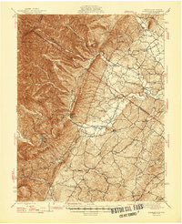
 1944 Staunton1961 Print · USGSThe Shenandoah Valley during the mid-forties remains a landscape of rail-connected trade centers and rural crossroads. Researchers can trace family roots through numerous country landmarks like Green Hill Cem, Franks Mill, and Jerusalem Chapel.2 unique versions available
 - 1945 Map of Craigsville
 1945 Craigsville1945 Print · USGSAugusta and Bath counties are shown here in the mid-1940s, when the rail lines still dictated the growth of mountain valley towns. Researchers can trace the Chesapeake and Ohio RR through Craigsville or locate rural sites like Rocky Spring Ch and Wilderness Sch.2 unique versions available
 - 1946 Map of Lovingston
 1946 Lovingston1946 Print · USGSNelson County and the eastern slopes of the Blue Ridge are captured here in the mid-1940s, just as the regional road network was maturing. Genealogists can locate family landmarks and community hubs like Lovingston, Massies Mill, and the Dutch Creek Sch.2 unique versions available
 - 1946 Map of Mc Dowell
 1946 Mc Dowell1946 Print · USGSHighland and Augusta counties are shown in the 1940s as a landscape of ridge-top landmarks and valley crossroads. Genealogists and local historians can trace family-named sites like Simons Mill, the historic Staunton and Parkersburg Turnpike, and rural congregations at St Pauls Ch.2 unique versions available
 - 1946 Map of Williamsville, 1964 Print
 1946 Williamsville1964 Print · USGSThe mountain valleys of Bath and Highland counties are captured here in the mid-1940s, showing a landscape of forest ridges and river settlements. Genealogists and hikers can locate old landmarks like Lockridge Memorial Ch, the Flood Sch, and the Duncan Knob Lookout Tower.
 - 1947 Map of Staunton
 1947 Staunton1947 Print · USGSAugusta County at the end of the Second World War shows a vibrant Shenandoah Valley hub centered on the railroad crossing at Staunton. Genealogists can locate family landmarks like Glebe Cem, St Johns Ch, and the outlying settlement of Stuarts Draft.2 unique versions available
 - 1947 Map of Parnassus
 1947 Parnassus1947 Print · USGSThe rural landscape of Augusta and Rockingham counties is captured here in the mid-1940s, showing the transition from fertile valley farms to high mountain ridges. Genealogists and historians can trace family locations near Natural Chimneys, Mt Solon, and the Payne Chapel schoolhouse.2 unique versions available
 - 1947 Map of Roanoke, 1948 Print
 1947 Roanoke1948 Print · USGSCentral Virginia in the late 1940s reveals a region defined by its great mountain ridges and the powerful river-and-rail economy connecting Roanoke to Lynchburg. Researchers can trace the path of the Virginian RR and locate historic county seats like Charlotte Court House.2 unique versions available
 - 1949 Map of Charlottesville
 1949 Charlottesville1949 Print · USGSThe Shenandoah Valley and Blue Ridge appear in the late 1940s as a thriving corridor of rail and river commerce. Researchers can trace the mid-century footprints of Harrisonburg, Staunton, and Culpeper alongside the historic routes of the Southern Railway.2 unique versions available
Showing maps 1-25 of 83
Top cities of Augusta County
- Stuarts Draft historical maps
- Verona historical maps
- Weyers Cave historical maps
- Crimora historical maps
- Lyndhurst historical maps
- Dooms historical maps
See more
Frequently asked questions
- What are the different types of historical maps available for Augusta County?
- What is the oldest map of Augusta County?
- Where can I purchase historical maps of Augusta County for my home or office?
- Where can I download high-res historical maps of Augusta County?
- Are there historical topographic maps available for Augusta County?
- Is there historical aerial imagery available for Augusta County?
- Where are historical maps of Augusta County sourced from?