1990s Maps of Augusta County, Virginia
Explore 12 historic maps of Augusta County from the 1990s. These maps offer a rare glimpse into what life looked like during the 1990s — showing old roads, neighborhoods, homes, and landmarks that have changed or disappeared over time.
Whether you're researching your family's past, planning a metal detecting trip, or studying how Augusta County's landscape evolved across the 1990s, these high-resolution maps are a powerful tool for exploring the history of this region.
- Focus on a specific era: All maps on this page are from the 1990s, giving you a focused view of this time period.
- See what’s changed: Compare century-old streets, trails, and buildings to today's modern landscape using overlays and satellite layers.
- Research with precision: Use these maps for genealogy, historical research, land use analysis, or educational projects.
- View, download, or print: Maps are fully viewable online in high resolution, and can be downloaded or printed for your own records.
Start exploring Augusta County's history through authentic maps from the 1990s. This is your window into the past.
Augusta County, VA maps
(12)- 1997 Map of Browns Cove, 1999 Print
 1997 Browns Cove1999 Print · USGSThe Albemarle and Rockingham county line meets the high ridges of the Blue Ridge in the late nineties, where mountain wilderness meets Piedmont valleys. Genealogists and hikers can trace the Appalachian Trail past Blackrock Shelter or locate rural landmarks like Browns Cove Ch and Sandridge Cem.
 - 1997 Map of Waynesboro East, 1999 Print
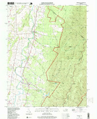
 1997 Waynesboro East1999 Print · USGSThe Blue Ridge peaks and the junction of three Virginia counties define this late-nineties landscape at the entrance to the Shenandoah Valley. Genealogists and historians can trace family-named sites like Critzer Shop, old country sanctuaries such as Mt Lebanon Ch, and landmarks like the Blue Ridge Tunnel.
 - 1997 Map of Crimora, 1999 Print
 1997 Crimora1999 Print · USGSAugusta County’s valley floor meets the Blue Ridge Mountains in the 1990s, where river-side communities sit in the shadow of the national park. Genealogists can trace local landmarks like Mt Bethel Ch, Mountain View Cem, and the railway hamlets of Harriston and Madrid.
 - 1998 Map of Staunton, 2001 Print
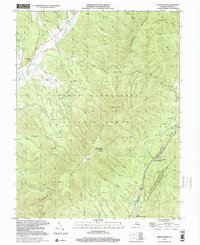
 1998 Staunton2001 Print · USGSStaunton and the Shenandoah Valley are depicted in the late nineties, showcasing the city's growth and its deep-seated educational and medical institutions. Researchers can locate Staunton National Cem, the Woodrow Wilson Birthplace, and historical mills like Quicks Mill along the river.
 - 1999 Map of Big Levels, 2000 Print
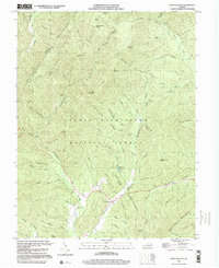
 1999 Big Levels2000 Print · USGSAugusta County mountain life and the high ridges of the Blue Ridge come into focus in this late-twentieth-century study. Genealogists and hikers can trace the winding Blue Ridge Parkway, the small settlement of Love, and historical mountain Mines.
 - 1999 Map of Reddish Knob, 2000 Print
 1999 Reddish Knob2000 Print · USGSThe mountain borderlands of Augusta and Rockingham counties are captured here in the late twentieth century. Researchers can trace historic access paths and high-country landmarks like Reddish Knob, the Hone Quarry Recreation Area, and scattered Mines.
 - 1999 Map of West Augusta, 2000 Print
 1999 West Augusta2000 Print · USGSThe mountain terrain of Augusta and Highland counties is captured here in the late 1990s, centered on the settlement of West Augusta. Genealogists and researchers can trace local family landmarks and burial sites like West Augusta Cem or explore the backcountry near Camp Todd and Braley Pond.
 - 1999 Map of Stokesville, 2000 Print
 1999 Stokesville2000 Print · USGSAugusta County remains a landscape of deep forest hollows and mountain gaps at the turn of the millennium. Local researchers can trace the rural footprints of Stokesville, find the site of Whites Store, or locate country churches like Paynes Chapel and Union Ch.
 - 1999 Map of Williamsville, 2000 Print
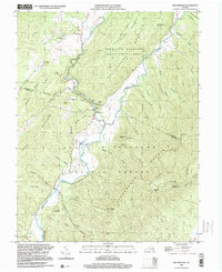 1999 Williamsville2000 Print · USGSThe river valleys of Bath and Highland Counties appear at the close of the twentieth century, centered on the convergence of the Bullpasture River and Cowpasture River. Local history researchers can trace family roots through settlements like Williamsville and Flood, or locate old landmarks including Mt Zion Ch and the Coursey Springs State Fish Hatchery.
 - 1999 Map of Palo Alto, 2000 Print
 1999 Palo Alto2000 Print · USGSThe borderlands of Augusta and Highland County meet West Virginia here in the late twentieth century, showing a landscape defined by ridges and narrow hollows. Genealogists can locate family landmarks such as Crummett Ch, Wilfong Ch, and the small settlement of Palo Alto.
 - 1999 Map of Mc Dowell, 2001 Print
 1999 Mc Dowell2001 Print · USGSHighland County at the end of the century remains a landscape of deep valleys and prominent ridges within the George Washington National Forest. Genealogists and historians can trace family locations near McDowell, Liberty, and the Hiner Ch, or locate the Columbia Union College Biological Station.
 - 1999 Map of Elliott Knob, 2001 Print
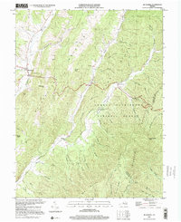
 1999 Elliott Knob2001 Print · USGSAugusta County’s high mountain ridges and forested hollows are shown here at the close of the twentieth century. Researchers can locate family landmarks like Ray Memorial Ch, trace the Calfpasture River, and find the Lookout Tower atop Elliott Knob.
End of results
Showing maps 1-12 of 12
Top cities of Augusta County
- Stuarts Draft historical maps
- Verona historical maps
- Weyers Cave historical maps
- Crimora historical maps
- Lyndhurst historical maps
- Dooms historical maps
See more
Frequently asked questions
- What are the different types of historical maps available for Augusta County?
- What is the oldest map of Augusta County?
- Where can I purchase historical maps of Augusta County for my home or office?
- Where can I download high-res historical maps of Augusta County?
- Are there historical topographic maps available for Augusta County?
- Is there historical aerial imagery available for Augusta County?
- Where are historical maps of Augusta County sourced from?