1950s Maps of Steeles Tavern, Virginia
Explore 3 historic maps of Steeles Tavern from the 1950s. These maps offer a rare glimpse into what life looked like during the 1950s — showing old roads, neighborhoods, homes, and landmarks that have changed or disappeared over time.
Whether you're researching your family's past, planning a metal detecting trip, or studying how Steeles Tavern's landscape evolved across the 1950s, these high-resolution maps are a powerful tool for exploring the history of this region.
- Focus on a specific era: All maps on this page are from the 1950s, giving you a focused view of this time period.
- See what’s changed: Compare century-old streets, trails, and buildings to today's modern landscape using overlays and satellite layers.
- Research with precision: Use these maps for genealogy, historical research, land use analysis, or educational projects.
- View, download, or print: Maps are fully viewable online in high resolution, and can be downloaded or printed for your own records.
Start exploring Steeles Tavern's history through authentic maps from the 1950s. This is your window into the past.
Steeles Tavern, VA maps
(3)- 1950 Map of Vesuvius, 1960 Print
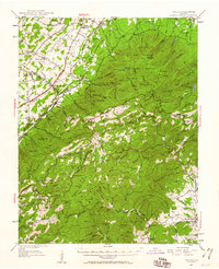 1950 Vesuvius1960 Print · USGSThe Blue Ridge high country of Augusta and Nelson counties comes alive in the mid-twentieth century, showing a landscape of remote mountain missions and state institutions. Genealogists and hikers can trace the Appalachian Trail past Irish Creek Mission, Montebello, and the State Prison Camp No 10.2 unique versions available
 - 1951 Map of Vesuvius
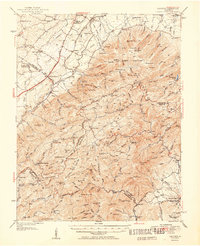 1951 Vesuvius1951 Print · USGSThe Blue Ridge foothills of Augusta and Rockbridge Counties are shown here in the early fifties, capturing a landscape of mountain missions and remote mines. Trace family history through Old Providence Ch, the Irish Creek Mission, and Massies Mill.2 unique versions available
 - 1959 Map of Roanoke
 1959 Roanoke1959 Print · USGSCentral Virginia and the Blue Ridge appear in great detail during the late fifties, showcasing the transition from mountain industry to Piedmont farmland. Trace the path of the Norfolk and Western railroad or find old river towns like Appomattox and Amelia Court House.
End of results
Showing maps 1-3 of 3
Top cities near Steeles Tavern
- Staunton historical maps
- Stuarts Draft historical maps
- Buena Vista historical maps
- Jolivue historical maps
- Craigsville historical maps
- Greenville historical maps
Frequently asked questions
- What are the different types of historical maps available for Steeles Tavern?
- What is the oldest map of Steeles Tavern?
- Where can I purchase historical maps of Steeles Tavern for my home or office?
- Where can I download high-res historical maps of Steeles Tavern?
- Are there historical topographic maps available for Steeles Tavern?
- Is there historical aerial imagery available for Steeles Tavern?
- Where are historical maps of Steeles Tavern sourced from?