1930s Maps of Bath County, Virginia
Explore 7 historic maps of Bath County from the 1930s. These maps offer a rare glimpse into what life looked like during the 1930s — showing old roads, neighborhoods, homes, and landmarks that have changed or disappeared over time.
Whether you're researching your family's past, planning a metal detecting trip, or studying how Bath County's landscape evolved across the 1930s, these high-resolution maps are a powerful tool for exploring the history of this region.
- Focus on a specific era: All maps on this page are from the 1930s, giving you a focused view of this time period.
- See what’s changed: Compare century-old streets, trails, and buildings to today's modern landscape using overlays and satellite layers.
- Research with precision: Use these maps for genealogy, historical research, land use analysis, or educational projects.
- View, download, or print: Maps are fully viewable online in high resolution, and can be downloaded or printed for your own records.
Start exploring Bath County's history through authentic maps from the 1930s. This is your window into the past.
Bath County, VA maps
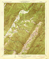
(7)- 1930 Map of Warm Springs Run
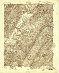 1930 Warm Springs Run1930 Print · USGSBath County's rugged ridge-and-valley landscape is captured here in the early 1930s as mountain communities remained deeply tied to their local terrain. Genealogists and historians can trace family locations near Thomastown, Mitchelltown, and schools like Thomastown Sch.2 unique versions available
 - 1930 Map of Mountain Grove
 1930 Mountain Grove1930 Print · USGSThe Virginia and West Virginia borderlands in the late 1920s are captured here during a time of isolated mountain settlements and river-bottom farming. Genealogists can trace family footprints through the numerous named hollows and crossings like Mcclintic Bridge, Mountain Grove, and Mooretown.
 - 1931 Map of Healing Springs
 1931 Healing Springs1931 Print · USGSBath County's famous resort corridor is captured here in the early thirties, showing a unique mix of high-society recreation and deep-hollow rural life. Genealogists and historians can trace family-named sites like Ashwood, Tinkertown, and the Indian Hill Sch.2 unique versions available
 - 1932 Map of Falling Spring
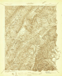
 1932 Falling Spring1932 Print · USGSThe Virginia and West Virginia borderlands in the early 1930s reveal a landscape of mountain ridges and riverside rail industry. Genealogists can trace family footprints at Greavers Mill, Jenkins Ford, and the old Cedar Creek Sch.3 unique versions available
 - 1933 Map of Mountain Grove
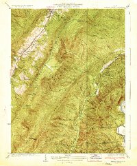
 1933 Mountain Grove1933 Print · USGSBath County's high ridges and river valleys are captured here in the early 1930s as a network of mountain hollows and small settlements. Genealogists and local historians can locate Mooretown, trace the namesake Mountain Grove, and find the Mailbox Sch and Eden Ch.3 unique versions available
 - 1933 Map of Warm Springs Run
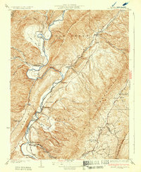
 1933 Warm Springs Run1933 Print · USGSBath County's central valley and surrounding ridges are captured here in the early 1930s, showing a landscape of tight-knit mountain communities. You can trace early school and church locations like The Gap Sch and Mt Hope Ch, or explore the historic layouts of Warm Springs and Bacova.3 unique versions available
 - 1933 Map of Healing Springs
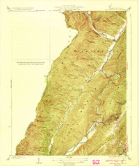
 1933 Healing Springs1933 Print · USGSBath County in the early 1930s is a landscape of mountain resorts and ridge-and-valley settlements. Researchers can trace the development of the springs at Hot Springs and Healing Springs, or find local landmarks like Oak Grove Sch and the Cascades Golf Club.3 unique versions available
End of results
Showing maps 1-7 of 7
Top cities of Bath County
Frequently asked questions
- What are the different types of historical maps available for Bath County?
- What is the oldest map of Bath County?
- Where can I purchase historical maps of Bath County for my home or office?
- Where can I download high-res historical maps of Bath County?
- Are there historical topographic maps available for Bath County?
- Is there historical aerial imagery available for Bath County?
- Where are historical maps of Bath County sourced from?