Old Maps of Bland County, Virginia
Explore 66 old maps of Bland County, spanning from 1887 to today. These high-resolution historic maps reveal how streets, neighborhoods, landmarks, and natural features evolved over time — perfect for genealogy, metal detecting, research, and local history exploration.
What you can do with these maps:
- See how Bland County changed over time: Compare historical maps to modern-day views to trace roads, homesites, rail lines & more.
- View detailed metadata: Each map includes creators, publishers, year, scale, and archive source.
- Overlay maps with satellite & LiDAR: Visualize the past alongside modern tools to explore terrain & human change.
- Trusted historical sources: Maps sourced from the USGS, Library of Congress, and other archives.
- Access maps your way: View online, download high-res files, or order prints for personal or research use.
Start exploring old maps of Bland County to uncover forgotten places, hidden landmarks, and the deep history beneath your feet.
Bland County, VA maps
(66)- 1887 Map of Pocahontas
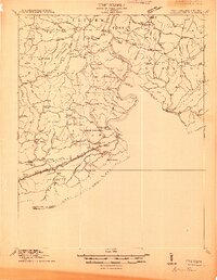
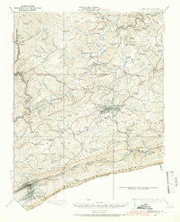
 1887 Pocahontas1887 Print · USGSThe Virginia and West Virginia borderlands are shown here in the 1880s as the coal industry and railroads began to reshape the Appalachian ridges. Genealogists can locate early settlements and landmarks like Seddon (Bland C. H.), the valley at Burks Garden, and the Concord Church congregation.
 - 1889 Map of Wytheville
 1889 Wytheville1889 Print · USGSSouthwestern Virginia and northwestern North Carolina are mapped here during the late nineteenth-century rise of the mountain iron industry. Genealogists and historians can locate early post offices and industrial sites such as Bridle Creek P.O., Eagle Furnace, and Rural Retreat.2 unique versions available
 - 1890 Map of Dublin
 1890 Dublin1890 Print · USGSThe mountainous borderlands of Virginia and West Virginia are captured here in the late nineteenth century as industry and rail expanded along the New River. Genealogists and historians can trace the foundations of local commerce through sites like Pearisburg, the Belle Hampton Mine, and river crossings at Peppers Ferry.
 - 1891 Map of Pocahontas
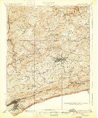
 1891 Pocahontas1891 Print · USGSThe Virginia and West Virginia borderlands are captured here during the late nineteenth-century expansion of the coal and rail industries. Genealogists and researchers can locate early settlements like Sedon (Bland CH), Spanishburg, and Pocahontas along the newly laid Norfolk and Western Railroad.
 - 1891 Map of Dublin
 1891 Dublin1891 Print · USGSAcross Southwest Virginia and West Virginia in the late nineteenth century, the river and rail lines dictated the pace of mountain life. Genealogists can trace family footprints through numerous river crossings like Ingles Ferry and historic industry sites like Altoona Mines and Mercers Salt Works.9 unique versions available
 - 1892 Map of Wytheville, 1897 Print
 1892 Wytheville1897 Print · USGSThe high ridges and river valleys of Southwest Virginia and Northwest North Carolina are captured here in the late nineteenth century. Genealogists can trace family footprints across the Iron Mountains to old industrial sites like White Rock Furnace and remote post offices such as Hampton P.O.6 unique versions available
 - 1894 Map of Pocahontas
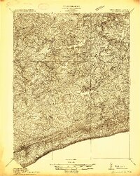
 1894 Pocahontas1894 Print · USGSThe Virginia and West Virginia borderlands are shown here during the late nineteenth-century coal boom. Researchers can trace early railroad expansion through settlements like Pocahontas or locate family roots in mountain basins such as Burke Garden and Sed Don.
 - 1895 Map of Pocahontas
 1895 Pocahontas1895 Print · USGSCoal mining towns and the Norfolk and Western RR line the border of Virginia and West Virginia in the late nineteenth century. Genealogists can trace the early layouts of Pocahontas, Bluefield, and the unusual enclosed valley of Burke Garden.6 unique versions available
 - 1913 Map of Peterstown
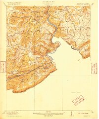
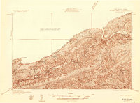
 1913 Peterstown1913 Print · USGSPeterstown and the New River valley are captured in the early twentieth century as the railroad transformed these mountain borderlands. Genealogists and historians can trace dozens of rural schoolhouses and stops like Willowton PO, Shanklins Ferry, and Oakvale.
 - 1913 Map of Bluefield
 1913 Bluefield1913 Print · USGSMercer County and the Virginia borderlands are captured here just before the Great War, showing a landscape of mountain ridges and river valleys. Genealogists and historians can locate dozens of early rural schoolhouses like Sand Gap School and Grecian Bend School, alongside the developing streets of Princeton and South Bluefield.
 - 1916 Map of Bluefield
 1916 Bluefield1916 Print · USGSMercer County and the Virginia border come alive in this survey of coal-country rail and mountain ridge communities. Genealogists can trace family roots through dozens of named schools like Sand Gap School and early post offices such as Hardy PO.
 - 1916 Map of Peterstown
 1916 Peterstown1916 Print · USGSMonroe and Mercer Counties are seen here in the decade before the First World War, defined by steep ridges and the critical rail corridors of the New River valley. Genealogists can locate dozens of country schools and remote landmarks like Mauvern Saltworks, Goodwin Chapel, and Shanklins Ferry.2 unique versions available
 - 1924 Map of Bluefield, 1966 Print
 1924 Bluefield1966 Print · USGSThe West Virginia and Virginia borderlands show significant growth in the mid-1920s as rail lines and mountain settlements expand. Genealogists can trace family names through dozens of rural landmarks like Mercer Healing Springs, Wenonah, and the Barber School.
 - 1925 Map of Peterstown
 1925 Peterstown1925 Print · USGSThe border of West Virginia and Virginia is captured in the mid-1920s, dominated by the winding path of the New River and the steep slopes of Peters Mtn. Genealogists can trace family locations near Mercers Saltworks, Wills Sta Willowton PO, and the Scratchgravel School.
 - 1926 Map of Bluefield
 1926 Bluefield1926 Print · USGSWest Virginia's southern highlands come into focus in the mid-1920s as the rail networks of the Norfolk and Western and Virginian RR expand. Family historians can trace rural life through dozens of local landmarks like Mercer Healing Springs, Pisgah Church, and the Willis White School.3 unique versions available
 - 1932 Map of Peterstown
 1932 Peterstown1932 Print · USGSThe borderlands of Giles and Mercer counties come alive in the early 1930s as the New River carves a path through the Appalachian ridges. Trace the rail-and-river economy of Narrows and find family-named landmarks like Blankenship Sch and Cedar Grove Ch.3 unique versions available
 - 1934 Map of Pulaski
 1934 Pulaski1934 Print · USGSPulaski and the surrounding Appalachian ridges are captured here during the mid-1930s, showing the intersection of mountain geography and local industry. Researchers can trace rural life through sites like the Stanse Mines, the Brick Church, and several valley schoolhouses including Long Spur Sch.
 - 1935 Map of Nebo
 1935 Nebo1935 Print · USGSSmyth County mountain valleys and the Holston River are mapped here in the mid-1930s. Genealogists can locate family landmarks like Tilson Mill, Groseclose Store, and rural schoolhouses including Nebo Sch.
 - 1935 Map of Nye Cove
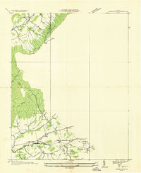
 1935 Nye Cove1935 Print · USGSTazewell and Bland counties are captured here in the mid-1930s as the rail and river economy centered on the Bluestone River shaped the borderlands. Genealogists and historians can trace family locations near West Graham P O, Shawver Mill, and local landmarks like Maple Hill Cem.
 - 1935 Map of Hutchinson Rock
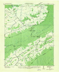
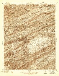
 1935 Hutchinson Rock1935 Print · USGSTazewell and Bland counties met along the high ridges of the Clinch Mountains during the mid-1930s. Researchers can trace early rural life through landmarks like Hutchinson Rock, the Thompson Sch, and several localized sites like Burkes Garden No 2.
 - 1935 Map of Garden Mountain
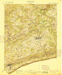
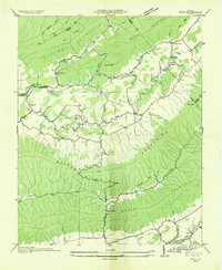
 1935 Garden Mountain1935 Print · USGSBland County highland valleys are captured in the mid-1930s as the Tennessee Valley Authority surveyed these mountain gaps. Genealogists can locate family homes and community centers near Sharon Springs, Little Town, and Red Oak Sch along the North Fork Holston River.
 - 1935 Map of Groseclose
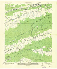
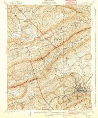
 1935 Groseclose1935 Print · USGSWythe County, Virginia, is captured in the mid-1930s along the vital Holston River transportation corridor. Genealogists and local historians can trace family land near Groseclose and Old Mt Airy, or locate community centers like Bethany Ch and Murpheyville Sch.
 - 1936 Map of Burkes Garden
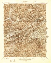
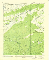
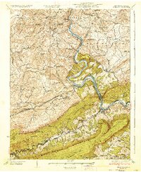
 1936 Burkes Garden1936 Print · USGSTazewell and Bland Counties appear in the mid-1930s, defined by the extraordinary limestone bowl of Burkes Garden. Genealogists and historians can trace family locations near Maple Hill Cem, the Witten Mill settlement, and the industrial corridor at Bluefield.
 - 1937 Map of Narrows
 1937 Narrows1937 Print · USGSThe New River corridor comes alive in the late 1930s, showing the vital rail and river connections between Virginia and West Virginia. Genealogists and historians can locate dozens of country schools, family-named ridges, and landmarks like Shanklins Ferry and Mercers Saltworks.4 unique versions available
 - 1940 Map of Pulaski
 1940 Pulaski1940 Print · USGSPulaski and the surrounding Blue Ridge foothills are captured in the mid-1930s as the railroad and timber industries shaped the local economy. Researchers can trace family sites near Shiloh Ch, locate the Stange Mines, or find old schoolhouses like Mill Iron Sch.3 unique versions available
Showing maps 1-25 of 66
Top cities of Bland County
Frequently asked questions
- What are the different types of historical maps available for Bland County?
- What is the oldest map of Bland County?
- Where can I purchase historical maps of Bland County for my home or office?
- Where can I download high-res historical maps of Bland County?
- Are there historical topographic maps available for Bland County?
- Is there historical aerial imagery available for Bland County?
- Where are historical maps of Bland County sourced from?