1960s Maps of Prater, Virginia
Explore 2 historic maps of Prater from the 1960s. These maps offer a rare glimpse into what life looked like during the 1960s — showing old roads, neighborhoods, homes, and landmarks that have changed or disappeared over time.
Whether you're researching your family's past, planning a metal detecting trip, or studying how Prater's landscape evolved across the 1960s, these high-resolution maps are a powerful tool for exploring the history of this region.
- Focus on a specific era: All maps on this page are from the 1960s, giving you a focused view of this time period.
- See what’s changed: Compare century-old streets, trails, and buildings to today's modern landscape using overlays and satellite layers.
- Research with precision: Use these maps for genealogy, historical research, land use analysis, or educational projects.
- View, download, or print: Maps are fully viewable online in high resolution, and can be downloaded or printed for your own records.
Start exploring Prater's history through authentic maps from the 1960s. This is your window into the past.
Prater, VA maps
(2)- 1960 Map of Jenkins
 1960 Jenkins1960 Print · USGSEastern Kentucky and the West Virginia borderlands are captured at a mid-century peak of the coal and rail era. Trace the industrial corridors of the Chesapeake and Ohio RR through mountain hubs like Hazard and Jenkins.
 - 1963 Map of Prater, 1964 Print
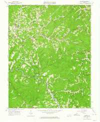 1963 Prater1964 Print · USGSBuchanan and Dickenson Counties are shown in the early sixties, where the winding Russell Fork dictates the shape of highland life. Genealogists can find numerous family landmarks, from Painter Cem to remote schools like the Upper Greenbrier Sch and Little Fox Sch.3 unique versions available
End of results
Showing maps 1-2 of 2
Top cities near Prater
- Elkhorn City historical maps
- Honaker historical maps
- Grundy historical maps
- Haysi historical maps
- Vansant historical maps
- Clinchco historical maps
See more
Frequently asked questions
- What are the different types of historical maps available for Prater?
- What is the oldest map of Prater?
- Where can I purchase historical maps of Prater for my home or office?
- Where can I download high-res historical maps of Prater?
- Are there historical topographic maps available for Prater?
- Is there historical aerial imagery available for Prater?
- Where are historical maps of Prater sourced from?