Old Maps of Buckingham County, Virginia for Academic Research
Study the evolution of Buckingham County with 68 high-resolution historic maps. Whether you're teaching, researching, or modeling changes in land use, these maps provide essential visual documentation of urban, environmental, and geographic change.
- Analyze long-term change: Track patterns in development, transportation, and natural features.
- Ideal for environmental or urban studies: Support academic projects with primary historical map data.
- Use in the classroom or lab: Educators and researchers rely on these maps to bring historical context to life.
These maps are a powerful tool for teaching, research, and visualizing how Buckingham County has changed over the decades.
Buckingham County, VA maps
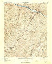
(68)- 1891 Map of Palmyra
 1891 Palmyra1891 Print · USGSCentral Virginia during the late nineteenth century was a landscape of river-driven industry and railroad expansion along the James. Genealogists and historians can locate old processing sites like Arvonia Slate Quarry, remote outposts like Boyds Tavern, and the track of the Richmond and Alleghany Railroad.
 - 1891 Map of Farmville
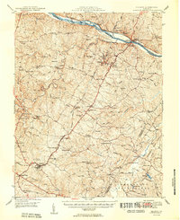
 1891 Farmville1891 Print · USGSSouth-central Virginia's rail and river networks come alive in the 1890s, centered on the bustling hub of Farmville. Genealogists can trace family roots through old courthouse seats like Cumberland C.H. and vanished stops like Jennings Ordinary or Rice Depot.
 - 1892 Map of Buckingham
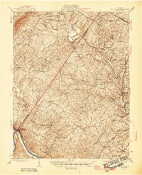
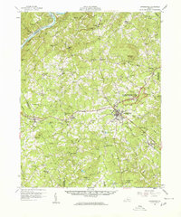
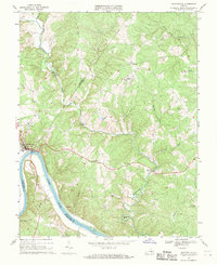
 1892 Buckingham1892 Print · USGSCentral Virginia in the late nineteenth century was defined by its river-and-rail economy along the James River. Genealogists and historians can trace the foundations of local life through the Kleinburg School, the Soap Stone Quarry, and the Virginia Midland Railroad.7 unique versions available
 - 1892 Map of Appomattox
 1892 Appomattox1892 Print · USGSCentral Virginia in the 1890s appears as a landscape of small agricultural hubs and vital river crossings. Genealogists can trace family names and landmarks like Morris Church, the Grave of Patrick Henry, and crossings such as Beazleys Ford.6 unique versions available
 - 1893 Map of Farmville
 1893 Farmville1893 Print · USGSThe Virginia Piedmont at the end of the nineteenth century centers on the rail junction at Farmville and the winding Appomattox River. Genealogists can trace family lands near Hampden Sidney, Guinea Mills, and the old tavern site at Joppings Ordinary.8 unique versions available
 - 1895 Map of Palmyra
 1895 Palmyra1895 Print · USGSThe James and Rivanna River valleys of central Virginia are captured here in the 1890s, revealing a landscape of rail-connected river towns and rural mills. Researchers can trace the Richmond and Alleghany Railroad and locate landmarks like the Arvon Slate Quarry or Flanagan Mill.
 - 1897 Map of Palmyra
 1897 Palmyra1897 Print · USGSCentral Virginia during the late 1880s is defined by its deep river valleys and the industrial reach of the James and Rivanna. Genealogists and historians can trace the growth of river towns like Scottsville or explore industrial roots at the Slate Quarry and Union Mills.7 unique versions available
 - 1929 Map of Covesville
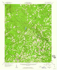
 1929 Covesville1929 Print · USGSAlbemarle County’s soapstone industry and mountain communities are frozen in time just before the Depression. Genealogists and historians can trace family locations near Alberene, old schools like Red Hill Sch, and landmarks including Forest Lodge and Johnson Mill.3 unique versions available
 - 1935 Map of Covesville, 1961 Print
 1935 Covesville1961 Print · USGSMid-century Albemarle County was defined by its soapstone industry and a dense network of country schools and chapels. Genealogists and historians can trace the foundations of local life through landmarks like Albermarle Soapstone Company, Cedar Vale Sch, and the riverside hub of Scottsville.
 - 1943 Map of Scottsville, 1969 Print
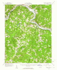
 1943 Scottsville1969 Print · USGSCentral Virginia’s river valleys and historic estates are preserved in this mid-century portrait of the Albemarle and Fluvanna borderlands. Researchers can trace ancestral locations at Ash Lawn, follow the Chesapeake and Ohio line through Nicholas Siding, or locate rural landmarks like Jefferson Mill.
 - 1945 Map of Covesville
 1945 Covesville1945 Print · USGSAlbemarle County's river valleys and mountain foothills are shown here in the mid-1940s, a period defined by the convergence of rail and river commerce. Genealogists and historians can trace family locations near Alberene, Esmont, and the Mt Zion Ch, or locate old industrial sites like Johnson Mill.
 - 1946 Map of Scottsville
 1946 Scottsville1946 Print · USGSCentral Virginia during the mid-1940s is shown here as a landscape of river-bend towns and quiet country crossroads. Genealogists and historians can trace family locations through named landmarks like Jefferson Mill, Blenheim, and Antioch Ch, or follow the historic Three Chopt Road.2 unique versions available
 - 1947 Map of Roanoke, 1948 Print
 1947 Roanoke1948 Print · USGSCentral Virginia in the late 1940s reveals a region defined by its great mountain ridges and the powerful river-and-rail economy connecting Roanoke to Lynchburg. Researchers can trace the path of the Virginian RR and locate historic county seats like Charlotte Court House.2 unique versions available
 - 1950 Map of Dillwyn
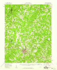
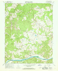
 1950 Dillwyn1950 Print · USGSBuckingham County's mid-century landscape is defined here by the river-and-rail corridor of the James River and the industrial activity near Dillwyn. Genealogists can trace family landmarks like Lower Bremo Mansion, Diana Mills P.O., and the Mourning Valley School.2 unique versions available
 - 1958 Map of Farmville, 1959 Print
 1958 Farmville1959 Print · USGSThe town of Farmville and its surrounding river counties are captured here in the late fifties. Researchers can trace the layout of Longwood College, locate rural landmarks like High Bridge, and identify numerous country schools such as Moton Sch.2 unique versions available
 - 1958 Map of Dillwyn, 1960 Print
 1958 Dillwyn1960 Print · USGSBuckingham and Fluvanna counties are captured in the late fifties along the industrial and historic James River corridor. Genealogists and historians can trace family roots through numerous country sites like Diana Mills, Mourning Valley Ch Cem, and Woodson High Sch.2 unique versions available
 - 1958 Map of Appomattox, 1960 Print
 1958 Appomattox1960 Print · USGSCentral Virginia is captured in the late fifties as the rail-side towns of Appomattox and Concord thrive. Genealogists can trace family landmarks like Earlys Chapel Cem and historic sites such as the McLean House.2 unique versions available
 - 1958 Map of Pamplin City, 1960 Print
 1958 Pamplin City1960 Print · USGSThe Virginia Piedmont in the late fifties is captured here through its network of forest reserves and small rail-side communities. Trace local family history through numerous landmarks like Pamplin City, Peaks Sch, and the Colonial Trail.
 - 1959 Map of Roanoke
 1959 Roanoke1959 Print · USGSCentral Virginia and the Blue Ridge appear in great detail during the late fifties, showcasing the transition from mountain industry to Piedmont farmland. Trace the path of the Norfolk and Western railroad or find old river towns like Appomattox and Amelia Court House.
 - 1960 Map of Lakeside Village, 1962 Print
 1960 Lakeside Village1962 Print · USGSThe James River and the Chesapeake and Ohio railroad shaped the Cumberland and Goochland borderlands during the early 1960s. Genealogists can trace family names and social centers through landmarks like Flippen Millpond, Little Fork Ch, and Muddy Creek Cem.2 unique versions available
 - 1961 Map of Shipman, 1963 Print
 1961 Shipman1963 Print · USGSNelson County's rugged ridges and the James River corridor are captured here in the early 1960s, showing a landscape defined by rail lines and rural community life. Researchers can trace historic church sites like White Rock Ch, the rail hub at Gladstone, and the grounds of the County Training Sch.2 unique versions available
 - 1961 Map of Buckingham, 1963 Print
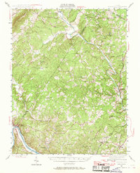
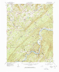
 1961 Buckingham1963 Print · USGSBuckingham County and the James River corridor are captured here in the early sixties as rural life centered on the river and rail. Genealogists can trace family roots through numerous country landmarks like Liberty Hall Cem, Midway Mills, and St Joy Sch.
 - 1963 Map of Roanoke
 1963 Roanoke1963 Print · USGSCentral Virginia and the Blue Ridge front appear here in the early sixties, caught between their deep railroad roots and new postwar developments. Genealogists and historians can trace the rail lines of the Norfolk and Western through towns like Bedford and Altavista, or locate family landmarks near Smith Mountain Lake.
 - 1967 Map of Esmont, 1968 Print
 1967 Esmont1968 Print · USGSAlbemarle County's Piedmont landscape is captured here in the late sixties, showing the vital river-and-rail corridor along the southern border. Genealogists and local historians can trace family locations near Esmont, Keene, and Scottsville, or find local landmarks like Yancy Sch and Dawson Mill.3 unique versions available
 - 1967 Map of Scottsville, 1969 Print
 1967 Scottsville1969 Print · USGSThe James River region at the end of the 1960s reveals a landscape defined by sharp river bends and industrial heritage. Genealogists and historians can trace family locations near Scottsville, Jefferson Mill, and rural landmarks like Fox Memorial Ch.2 unique versions available
Showing maps 1-25 of 68
Top cities of Buckingham County
Frequently asked questions
- What are the different types of historical maps available for Buckingham County?
- What is the oldest map of Buckingham County?
- Where can I purchase historical maps of Buckingham County for my home or office?
- Where can I download high-res historical maps of Buckingham County?
- Are there historical topographic maps available for Buckingham County?
- Is there historical aerial imagery available for Buckingham County?
- Where are historical maps of Buckingham County sourced from?