1960s Maps of Altavista, Virginia
Explore 4 historic maps of Altavista from the 1960s. These maps offer a rare glimpse into what life looked like during the 1960s — showing old roads, neighborhoods, homes, and landmarks that have changed or disappeared over time.
Whether you're researching your family's past, planning a metal detecting trip, or studying how Altavista's landscape evolved across the 1960s, these high-resolution maps are a powerful tool for exploring the history of this region.
- Focus on a specific era: All maps on this page are from the 1960s, giving you a focused view of this time period.
- See what’s changed: Compare century-old streets, trails, and buildings to today's modern landscape using overlays and satellite layers.
- Research with precision: Use these maps for genealogy, historical research, land use analysis, or educational projects.
- View, download, or print: Maps are fully viewable online in high resolution, and can be downloaded or printed for your own records.
Start exploring Altavista's history through authentic maps from the 1960s. This is your window into the past.
Altavista, VA maps
(4)- 1963 Map of Roanoke
 1963 Roanoke1963 Print · USGSCentral Virginia and the Blue Ridge front appear here in the early sixties, caught between their deep railroad roots and new postwar developments. Genealogists and historians can trace the rail lines of the Norfolk and Western through towns like Bedford and Altavista, or locate family landmarks near Smith Mountain Lake.
 - 1966 Map of Castle Craig, 1967 Print
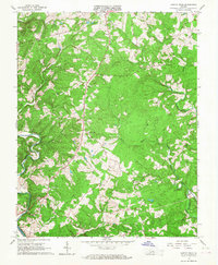 1966 Castle Craig1967 Print · USGSCampbell County land and the river forks are captured here in the mid-1960s as rural life centered on crossroads and creek valleys. Genealogists can trace family roots through numerous local landmarks like Liberty Ch, Salem Ch, and Altavista Memorial Park.3 unique versions available
 - 1966 Map of Lynch Station, 1968 Print
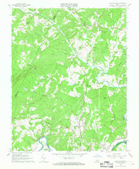 1966 Lynch Station1968 Print · USGSSouthern Campbell County is captured here in the mid-sixties, a landscape defined by the intersection of the Southern railroad and the Big Otter River. Genealogists and local historians can trace the foundations of rural life through numerous country churches like Mt Hermon Ch and the historic settlement at Lynch Station.4 unique versions available
 - 1966 Map of Altavista, 1968 Print
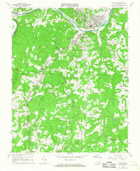 1966 Altavista1968 Print · USGSThe Roanoke River valley in the mid-1960s shows a region defined by its rail-and-river economy and growing industrial towns. Genealogists and historians can trace the rural landscape surrounding Altavista through landmarks like Moriah Ch, Hill Grove, and Jasper Mountain.3 unique versions available
End of results
Showing maps 1-4 of 4
Top cities near Altavista
- Timberlake historical maps
- Forest historical maps
- Bedford historical maps
- Rustburg historical maps
- Gretna historical maps
- Hurt historical maps
See more
Top neighborhoods of Altavista
- Founder's Square historical maps
- Gateway Park historical maps
- Main Street District historical maps
- Winden Hills historical maps
- Riverview Heights historical maps
- Seminole Ridge historical maps
See more
Frequently asked questions
- What are the different types of historical maps available for Altavista?
- What is the oldest map of Altavista?
- Where can I purchase historical maps of Altavista for my home or office?
- Where can I download high-res historical maps of Altavista?
- Are there historical topographic maps available for Altavista?
- Is there historical aerial imagery available for Altavista?
- Where are historical maps of Altavista sourced from?