1960s Maps of Lake Land'Or, Virginia
Explore 4 historic maps of Lake Land'Or from the 1960s. These maps offer a rare glimpse into what life looked like during the 1960s — showing old roads, neighborhoods, homes, and landmarks that have changed or disappeared over time.
Whether you're researching your family's past, planning a metal detecting trip, or studying how Lake Land'Or's landscape evolved across the 1960s, these high-resolution maps are a powerful tool for exploring the history of this region.
- Focus on a specific era: All maps on this page are from the 1960s, giving you a focused view of this time period.
- See what’s changed: Compare century-old streets, trails, and buildings to today's modern landscape using overlays and satellite layers.
- Research with precision: Use these maps for genealogy, historical research, land use analysis, or educational projects.
- View, download, or print: Maps are fully viewable online in high resolution, and can be downloaded or printed for your own records.
Start exploring Lake Land'Or's history through authentic maps from the 1960s. This is your window into the past.
Lake Land'Or, VA maps
(4)- 1961 Map of Washington
 1961 Washington1961 Print · USGSThe mid-Atlantic region in the late fifties is presented in remarkable detail, from the Blue Ridge foothills to the Chesapeake Eastern Shore. Researchers can trace historic river landings and military sites like Mount Vernon, Fort Belvoir, and Point Lookout.2 unique versions available
 - 1964 Map of Richmond
 1964 Richmond1964 Print · USGSCoastal and central Virginia are mapped during the mid-twentieth century, showing the critical intersection of rail, river, and military life. Genealogists can trace family roots through rural county seats like Amelia or find vanished coastal neighborhoods near Phoebus and Hilton Village.
 - 1966 Map of Ladysmith, 1968 Print
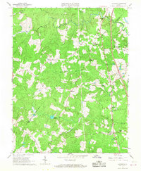 1966 Ladysmith1968 Print · USGSThe rural Virginia interior comes into focus during the mid-sixties as the county lines of Caroline and Spotsylvania meet among tangled river forks. Genealogists can trace family footprints at Nancy Wrights Corner, Blades Corner, and historic congregations like Wrights Chapel.4 unique versions available
 - 1969 Map of Hewlett, 1971 Print
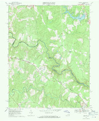 1969 Hewlett1971 Print · USGSCaroline and Hanover counties are captured here in the late sixties as the river-and-rail landscape began to see new development. Genealogists can locate family landmarks like Mt Salem Ch, trace the Chesapeake and Ohio rail line, and find small communities like Hewlett and Chilesburg.4 unique versions available
End of results
Showing maps 1-4 of 4
Top cities near Lake Land'Or
Frequently asked questions
- What are the different types of historical maps available for Lake Land'Or?
- What is the oldest map of Lake Land'Or?
- Where can I purchase historical maps of Lake Land'Or for my home or office?
- Where can I download high-res historical maps of Lake Land'Or?
- Are there historical topographic maps available for Lake Land'Or?
- Is there historical aerial imagery available for Lake Land'Or?
- Where are historical maps of Lake Land'Or sourced from?