1960s Maps of Ettrick, Virginia
Explore 3 historic maps of Ettrick from the 1960s. These maps offer a rare glimpse into what life looked like during the 1960s — showing old roads, neighborhoods, homes, and landmarks that have changed or disappeared over time.
Whether you're researching your family's past, planning a metal detecting trip, or studying how Ettrick's landscape evolved across the 1960s, these high-resolution maps are a powerful tool for exploring the history of this region.
- Focus on a specific era: All maps on this page are from the 1960s, giving you a focused view of this time period.
- See what’s changed: Compare century-old streets, trails, and buildings to today's modern landscape using overlays and satellite layers.
- Research with precision: Use these maps for genealogy, historical research, land use analysis, or educational projects.
- View, download, or print: Maps are fully viewable online in high resolution, and can be downloaded or printed for your own records.
Start exploring Ettrick's history through authentic maps from the 1960s. This is your window into the past.
Ettrick, VA maps
(3)- 1964 Map of Richmond
 1964 Richmond1964 Print · USGSCoastal and central Virginia are mapped during the mid-twentieth century, showing the critical intersection of rail, river, and military life. Genealogists can trace family roots through rural county seats like Amelia or find vanished coastal neighborhoods near Phoebus and Hilton Village.
 - 1969 Map of Petersburg, 1971 Print
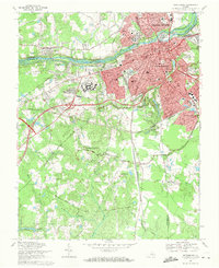 1969 Petersburg1971 Print · USGSPetersburg and Colonial Heights are shown in the late sixties as the urban core expands alongside a landscape defined by Civil War history. Researchers can trace numerous fortifications like Fort Wadsworth and locate family sites at Blandford Cemetery or Smith Grove Ch.3 unique versions available
 - 1969 Map of Chester, 1971 Print
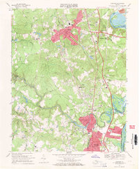 1969 Chester1971 Print · USGSThe corridor between Richmond and Petersburg was undergoing rapid suburban growth in the late sixties. Genealogists and local historians can trace family-named sites and vanished infrastructure from Lynch Siding and Bethesda Ch to the historic crossings at Branders Bridge.4 unique versions available
End of results
Showing maps 1-3 of 3
Top cities near Ettrick
- Petersburg historical maps
- Chester historical maps
- Hopewell historical maps
- Meadowbrook historical maps
- Colonial Heights historical maps
- Fort Gregg-Adams historical maps
See more
Top neighborhoods of Ettrick
- Brander's Estates historical maps
- Brookside historical maps
- Braebrook Village historical maps
- Cook's Plan historical maps
- College Park historical maps
- Bollinger Estates historical maps
See more
Frequently asked questions
- What are the different types of historical maps available for Ettrick?
- What is the oldest map of Ettrick?
- Where can I purchase historical maps of Ettrick for my home or office?
- Where can I download high-res historical maps of Ettrick?
- Are there historical topographic maps available for Ettrick?
- Is there historical aerial imagery available for Ettrick?
- Where are historical maps of Ettrick sourced from?