1930s Maps of Clarke County, Virginia
Explore 4 historic maps of Clarke County from the 1930s. These maps offer a rare glimpse into what life looked like during the 1930s — showing old roads, neighborhoods, homes, and landmarks that have changed or disappeared over time.
Whether you're researching your family's past, planning a metal detecting trip, or studying how Clarke County's landscape evolved across the 1930s, these high-resolution maps are a powerful tool for exploring the history of this region.
- Focus on a specific era: All maps on this page are from the 1930s, giving you a focused view of this time period.
- See what’s changed: Compare century-old streets, trails, and buildings to today's modern landscape using overlays and satellite layers.
- Research with precision: Use these maps for genealogy, historical research, land use analysis, or educational projects.
- View, download, or print: Maps are fully viewable online in high resolution, and can be downloaded or printed for your own records.
Start exploring Clarke County's history through authentic maps from the 1930s. This is your window into the past.
Clarke County, VA maps
(4)- 1937 Map of Gerrardstown
 1937 Gerrardstown1937 Print · USGSSettlements and old wagon roads thread through the Shenandoah Valley in the late 1930s. Genealogists can trace family names and social hubs like Howards Chapel, the Hopewell Meeting House, and the historic Braddock Road.3 unique versions available
 - 1938 Map of Winchester
 1938 Winchester1938 Print · USGSThe Shenandoah Valley appears here in the late 1930s as a vital crossroads of rail and road. Genealogists and historians can trace old homesteads and landmarks like Greenway Court, the Civil War-era Star Fort, and Berrys Ferry Bridge.
 - 1939 Map of Front Royal
 1939 Front Royal1939 Print · USGSThe Blue Ridge foothills and Front Royal are shown here during the late 1930s as the national park and military reservations were being established. Genealogists and historians can trace family locations through numerous rural institutions like Mt Paran Ch, Lottie Sch, and Miller Cem.2 unique versions available
 - 1939 Map of Berryville
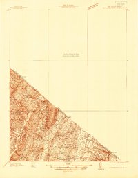
 1939 Berryville1939 Print · USGSNorthern Virginia and the West Virginia borderlands appear here in the late thirties as a landscape of river fords and mountain gaps. Genealogists can trace family names at Locke Mill, Shepherd Ford, and the Mt Olive Cem.
End of results
Showing maps 1-4 of 4
Top cities of Clarke County
Frequently asked questions
- What are the different types of historical maps available for Clarke County?
- What is the oldest map of Clarke County?
- Where can I purchase historical maps of Clarke County for my home or office?
- Where can I download high-res historical maps of Clarke County?
- Are there historical topographic maps available for Clarke County?
- Is there historical aerial imagery available for Clarke County?
- Where are historical maps of Clarke County sourced from?