Old Maps of Clarke County, Virginia for Genealogy
Trace your family roots with 80 historic maps of Clarke County. These high-res maps reveal old neighborhoods, homesites, landmarks, and streets — helping you uncover where your ancestors lived and how the area evolved over time.
- Explore historic neighborhoods: Identify where your relatives may have lived in the 1800s or 1900s.
- Compare maps over time: Trace the changes in streets, buildings, and landmarks for multi-generational research.
- Perfect for genealogy & ancestry research: Used by family historians and researchers to map out lineage and migration.
These maps are an incredible resource for exploring your personal connection to Clarke County's past.
Clarke County, VA maps
(80)- 1884 Map of Harpers Ferry
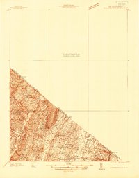
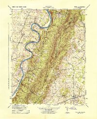
 1884 Harpers Ferry1884 Print · USGSThe confluence of the Potomac and Shenandoah rivers is captured in the mid-1880s, documenting a landscape of strategic gaps and vital transit corridors. Researchers can trace the path of the Chesapeake and Ohio Canal and locate historic river crossings like Conrad Ferry and Castleman Ferry.
 - 1891 Map of Harpers Ferry
 1891 Harpers Ferry1891 Print · USGSThe tri-state borderlands of the Potomac and Shenandoah valleys were a vital hub of transport and trade in the late 1800s. Researchers can trace historic river crossings like Castlemans Ferry, follow the route of the Chesapeake and Ohio Canal, or locate family-named settlements like Oatlands and Taylorstown.
 - 1893 Map of Luray, 1898 Print
 1893 Luray1898 Print · USGSThe Shenandoah Valley in the 1890s was a land of steep mountain ridges and vital new railways. Genealogists and historians can trace old homesteads and depots along the Shenandoah Valley Railroad or find remote hamlets like Seven Fountains and Browntown.
 - 1893 Map of Harpers Ferry, 1898 Print
 1893 Harpers Ferry1898 Print · USGSThe tri-state region of the Potomac and Shenandoah valleys is captured here in the late nineteenth century, showing a landscape defined by water and rail. Trace the historic Chesapeake and Ohio Canal or locate local landmarks like Snyder Mills and Harpers Ferry.7 unique versions available
 - 1894 Map of Warrenton
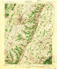
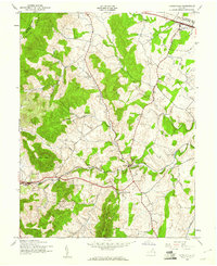
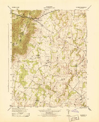
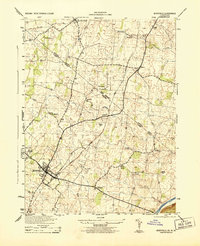
 1894 Warrenton1894 Print · USGSVirginia's northern Piedmont and mountain gaps are mapped here in the late nineteenth century as the rail-and-river economy flourished. Genealogists can trace family names and small crossroads from Warrenton and Brentsville to White Sulphur Springs.9 unique versions available
 - 1894 Map of Winchester, 1899 Print
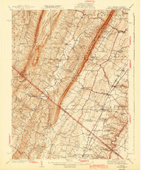
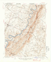
 1894 Winchester1899 Print · USGSThe Virginia and West Virginia borderlands appear here in the late nineteenth century, showing a landscape defined by mountain ridges and bustling rail junctions. Researchers can trace early rural life through family-named sites like Unger Store and Fawcetts Gap or the resort history of Capon Springs.6 unique versions available
 - 1905 Map of Luray, 1910 Print
 1905 Luray1910 Print · USGSThe Blue Ridge and Shenandoah Valley are frozen in time just after the turn of the century, showing the critical rail networks and mountain gaps of the period. Genealogists can trace family names and settlements like Luray, Front Royal, and Strasburg along the Shenandoah Valley Railroad.4 unique versions available
 - 1914 Map of Gerrardstown
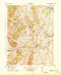
 1914 Gerrardstown1914 Print · USGSBerkeley County was a landscape of mountain ridges and orchard valleys just before the Great War. Researchers can locate vanished landmarks like the Toll Gate at Darkesville or early rural institutions such as the Gerrardstown Colored School.
 - 1916 Map of Gerrardstown
 1916 Gerrardstown1916 Print · USGSThe West Virginia and Virginia borderlands come alive in this mid-1910s study of the ridgelines and valley roads. Genealogists can trace family roots at Salem Church and Tuscarora Church or locate vanished landmarks like the Tollgate and County Home.
 - 1916 Map of Berryville, 1920 Print
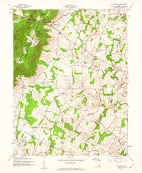
 1916 Berryville1920 Print · USGSThe lower Shenandoah Valley at the onset of the Great War was a landscape defined by its river ferries and growing rail lines. Genealogists and historians can trace the foundations of local life through rural landmarks like Mountain Mission, Furnace School, and the river crossing at Shannondale Ferry.2 unique versions available
 - 1937 Map of Gerrardstown
 1937 Gerrardstown1937 Print · USGSSettlements and old wagon roads thread through the Shenandoah Valley in the late 1930s. Genealogists can trace family names and social hubs like Howards Chapel, the Hopewell Meeting House, and the historic Braddock Road.3 unique versions available
 - 1938 Map of Winchester
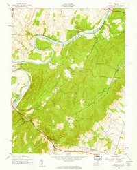
 1938 Winchester1938 Print · USGSThe Shenandoah Valley appears here in the late 1930s as a vital crossroads of rail and road. Genealogists and historians can trace old homesteads and landmarks like Greenway Court, the Civil War-era Star Fort, and Berrys Ferry Bridge.
 - 1939 Map of Front Royal
 1939 Front Royal1939 Print · USGSThe Blue Ridge foothills and Front Royal are shown here during the late 1930s as the national park and military reservations were being established. Genealogists and historians can trace family locations through numerous rural institutions like Mt Paran Ch, Lottie Sch, and Miller Cem.2 unique versions available
 - 1939 Map of Berryville
 1939 Berryville1939 Print · USGSNorthern Virginia and the West Virginia borderlands appear here in the late thirties as a landscape of river fords and mountain gaps. Genealogists can trace family names at Locke Mill, Shepherd Ford, and the Mt Olive Cem.
 - 1942 Map of Winchester
 1942 Winchester1942 Print · USGSThe Shenandoah Valley during the early years of the war shows a landscape of busy pikes and vital rail junctions. Researchers can trace historic fortifications like Star Fort, family sites at Ridings Mill, and landmarks like Greenway Court.3 unique versions available
 - 1943 Map of Gerrardstown
 1943 Gerrardstown1943 Print · USGSBerkeley County and the West Virginia-Virginia borderlands are captured here during the mid-1940s as a thriving network of valley settlements and mountain gaps. Researchers can locate family landmarks like the Old Stone Ch, the County Home, and the old Tollgate at Inwood.
 - 1943 Map of Bluemont, 1960 Print
 1943 Bluemont1960 Print · USGSLoudoun County’s rural heritage is preserved here in the 1940s, showing the ridge-and-valley landscape before modern development. Genealogists can trace family roots through settlements like Unison and Willisville, and landmarks like Ebenezer Ch.
 - 1943 Map of Ashby Gap, 1961 Print
 1943 Ashby Gap1961 Print · USGSThe Blue Ridge mountains and Shenandoah Valley meet in the early 1940s, showing a landscape of high ridges and winding river bends. Trace the path of the Appalachian Trail past Mt Weather or locate rural landmarks like Mt Carmel Ch and Millwood.
 - 1943 Map of Upperville, 1961 Print
 1943 Upperville1961 Print · USGSNorthern Virginia's Piedmont and Blue Ridge foothills are captured here during the early 1940s. Genealogists can trace family footprints at Upperville, Delaplane, and Markham, or locate landmarks like Pennys Hill Sch and the SOUTHERN rail line.
 - 1944 Map of Round Hill
 1944 Round Hill1944 Print · USGSThe Virginia and West Virginia borderlands are captured here during the mid-forties, showing the river-carved landscape of the Blue Ridge. Researchers can trace the path of the Appalachian Trail or locate local landmarks like Mountain Mission and Round Hill.
 - 1944 Map of Upperville
 1944 Upperville1944 Print · USGSThe Fauquier County countryside during the mid-1940s shows a landscape of prominent ridges and rural crossroads. Genealogists and local historians can trace the paths between Delaplane and Markham, locating landmarks like Fleetwood Roller Mills and the Fennys Hill School.
 - 1944 Map of Bluemont
 1944 Bluemont1944 Print · USGSLoudoun County is shown in the mid-1940s as a landscape of mountain gaps and established rural hamlets. Genealogists and researchers can trace the locations of Pine Grove School, Ebenezer Church, and the winding Appalachian Trail.
 - 1944 Map of Berryville
 1944 Berryville1944 Print · USGSBerryville and the fertile Clarke County farmlands are captured in the 1940s as the rail lines of the Norfolk and Western and Baltimore and Ohio shaped local trade. Genealogists and historians can trace family locations near Beulah Church, Peagans Mill, and Rippon.
 - 1944 Map of Berryville
 1944 Berryville1944 Print · USGSThe Virginia and West Virginia borderlands are captured here in the mid-1940s, showing the agricultural valley around Berryville meeting the steep Blue Ridge. Researchers can trace the path of the Appalachian Trail or locate vanished landmarks like Boyds Ferry and the Yellow Schoolhouse.
 - 1944 Map of Front Royal
 1944 Front Royal1944 Print · USGSFront Royal and the northern Blue Ridge Mountains appear here during the mid-forties as industrial growth and federal land projects reshaped the valley. Researchers can trace family sites like Miller Cem, explore the early Skyline Drive, and locate schools such as Harmony Hollow Sch.2 unique versions available
Showing maps 1-25 of 80
Top cities of Clarke County
Frequently asked questions
- What are the different types of historical maps available for Clarke County?
- What is the oldest map of Clarke County?
- Where can I purchase historical maps of Clarke County for my home or office?
- Where can I download high-res historical maps of Clarke County?
- Are there historical topographic maps available for Clarke County?
- Is there historical aerial imagery available for Clarke County?
- Where are historical maps of Clarke County sourced from?