1910s Maps of Essex County, Virginia
Explore 7 historic maps of Essex County from the 1910s. These maps offer a rare glimpse into what life looked like during the 1910s — showing old roads, neighborhoods, homes, and landmarks that have changed or disappeared over time.
Whether you're researching your family's past, planning a metal detecting trip, or studying how Essex County's landscape evolved across the 1910s, these high-resolution maps are a powerful tool for exploring the history of this region.
- Focus on a specific era: All maps on this page are from the 1910s, giving you a focused view of this time period.
- See what’s changed: Compare century-old streets, trails, and buildings to today's modern landscape using overlays and satellite layers.
- Research with precision: Use these maps for genealogy, historical research, land use analysis, or educational projects.
- View, download, or print: Maps are fully viewable online in high resolution, and can be downloaded or printed for your own records.
Start exploring Essex County's history through authentic maps from the 1910s. This is your window into the past.
Essex County, VA maps
(7)- 1917 Map of Urbanna
 1917 Urbanna1917 Print · USGSMiddlesex and Lancaster Counties come alive in this survey of the Virginia Tidewater during the Great War era. Researchers can trace ancestral roots through dozens of local landmarks like Christ Church, Healys Mill, and Royal Oak School.3 unique versions available
 - 1917 Map of Morattico
 1917 Morattico1917 Print · USGSThe Northern Neck of Virginia is shown here in the years before the Great War, when the Rappahannock River was a busy Steamboat Route. Genealogists can locate family landmarks like Gordys Millpond, Lively, and the Marvin Grove Camp in this detailed look at early rural life.
 - 1918 Map of Tappahannock
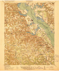 1918 Tappahannock1918 Print · USGSThe Tidewater region during the first World War comes alive on this sheet, centered on the historic river crossing at Tappahannock. Researchers can trace the active Steamboat Route, old river landings like Bowlers Wharf, and rural landmarks including St Pauls Church.2 unique versions available
 - 1918 Map of Aylett
 1918 Aylett1918 Print · USGSThe rural landscapes of King and Queen and King William counties are captured here at the end of the Great War. Researchers can trace ancestral connections through old mill sites and churches like Aylett Mill, St Stephens Church, and Shiloh Church.
 - 1918 Map of Morattico
 1918 Morattico1918 Print · USGSThe Northern Neck region relied heavily on the Rappahannock waterfront during the early twentieth century, when steamboats were still the primary connection to the outside world. Researchers can trace ancestral home sites and community centers from Lodge and Nuttsville to historic landmarks like Gibeon Church and Downings Mill.3 unique versions available
 - 1919 Map of New Kent
 1919 New Kent1919 Print · USGSThe Virginia tidewater comes to life in the years following the Great War, showing the convergence of the Mattaponi and Pamunkey rivers. Genealogists can trace family roots through the Pamunkey Indian Reservation, West Point, and rural landmarks like Mattaponi Church or Frazier Ferry.3 unique versions available
 - 1919 Map of Tappahannock, 1938 Print
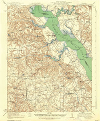 1919 Tappahannock1938 Print · USGSCoastal life along the Rappahannock River is meticulously charted here in the years following the Great War. Genealogists and historians can trace the foundations of Essex and Richmond counties through landmarks like Millers Tavern, the Rappahannock Industrial Academy, and Mt Airy Millpond.
End of results
Showing maps 1-7 of 7
Top cities of Essex County
Frequently asked questions
- What are the different types of historical maps available for Essex County?
- What is the oldest map of Essex County?
- Where can I purchase historical maps of Essex County for my home or office?
- Where can I download high-res historical maps of Essex County?
- Are there historical topographic maps available for Essex County?
- Is there historical aerial imagery available for Essex County?
- Where are historical maps of Essex County sourced from?