1930s Maps of Essex County, Virginia
Explore 3 historic maps of Essex County from the 1930s. These maps offer a rare glimpse into what life looked like during the 1930s — showing old roads, neighborhoods, homes, and landmarks that have changed or disappeared over time.
Whether you're researching your family's past, planning a metal detecting trip, or studying how Essex County's landscape evolved across the 1930s, these high-resolution maps are a powerful tool for exploring the history of this region.
- Focus on a specific era: All maps on this page are from the 1930s, giving you a focused view of this time period.
- See what’s changed: Compare century-old streets, trails, and buildings to today's modern landscape using overlays and satellite layers.
- Research with precision: Use these maps for genealogy, historical research, land use analysis, or educational projects.
- View, download, or print: Maps are fully viewable online in high resolution, and can be downloaded or printed for your own records.
Start exploring Essex County's history through authentic maps from the 1930s. This is your window into the past.
Essex County, VA maps
(3)- 1930 Map of Wakefield
 1930 Wakefield1930 Print · USGSWestmoreland County and the Northern Neck appear here in the early thirties, defined by a historic riverfront landscape and rural hamlets. Researchers can locate the Birthplace of Washington and Monroe Birthplace alongside old river ports like Leedstown and Steve Landing.
 - 1932 Map of Wakefield
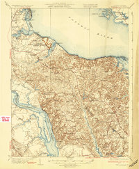 1932 Wakefield1932 Print · USGSWestmoreland County at the start of the 1930s shows a landscape defined by the great bends of the Potomac and Rappahannock Rivers. Researchers can trace ancestral locations near the George Washington Birthplace or find local landmarks like Potomac Mills and Monroe Hall.2 unique versions available
 - 1933 Map of Aylett
 1933 Aylett1933 Print · USGSCoastal Plain Virginia during the 1930s shows a landscape of river-based commerce and tight-knit farming communities. Genealogists and historians can trace family locations near Aylett, locate the Millfork School, or find old mills like Dublin Mill.2 unique versions available
End of results
Showing maps 1-3 of 3
Top cities of Essex County
Frequently asked questions
- What are the different types of historical maps available for Essex County?
- What is the oldest map of Essex County?
- Where can I purchase historical maps of Essex County for my home or office?
- Where can I download high-res historical maps of Essex County?
- Are there historical topographic maps available for Essex County?
- Is there historical aerial imagery available for Essex County?
- Where are historical maps of Essex County sourced from?