1940s Maps of Hustle, Virginia
Explore 3 historic maps of Hustle from the 1940s. These maps offer a rare glimpse into what life looked like during the 1940s — showing old roads, neighborhoods, homes, and landmarks that have changed or disappeared over time.
Whether you're researching your family's past, planning a metal detecting trip, or studying how Hustle's landscape evolved across the 1940s, these high-resolution maps are a powerful tool for exploring the history of this region.
- Focus on a specific era: All maps on this page are from the 1940s, giving you a focused view of this time period.
- See what’s changed: Compare century-old streets, trails, and buildings to today's modern landscape using overlays and satellite layers.
- Research with precision: Use these maps for genealogy, historical research, land use analysis, or educational projects.
- View, download, or print: Maps are fully viewable online in high resolution, and can be downloaded or printed for your own records.
Start exploring Hustle's history through authentic maps from the 1940s. This is your window into the past.
Hustle, VA maps
(3)- 1942 Map of Occupacia
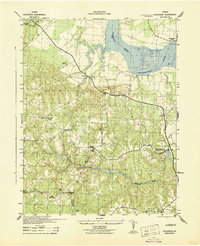 1942 Occupacia1942 Print · USGSEssex County's riverfront and rural interior are documented here during the early 1940s, showing a landscape of crossroads settlements and timber resources. Genealogists and historians can trace family locations near Vauters Church, Bethlehem Fork, and the Lumber Mill near Iraville.
 - 1948 Map of Washington
 1948 Washington1948 Print · USGSThe Potomac and Chesapeake regions in the late 1940s reveal a landscape of expanding military reach and deep-rooted Tidewater settlements. Trace old rail corridors like the Richmond Fredericksburg & Potomac RR or locate landmarks like the Wakefield Washington Monument and St. Marys College.2 unique versions available
 - 1949 Map of Occupacia, 1961 Print
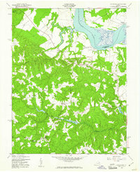 1949 Occupacia1961 Print · USGSCoastal Virginia near the Rappahannock River is captured here in the late 1940s, showing a traditional landscape of millponds and rural parishes. Researchers can locate historic landmarks such as Vauters Ch and Hunters Millpond alongside crossroads like Hustle.
End of results
Showing maps 1-3 of 3
Top cities near Hustle
- King George historical maps
- Colonial Beach historical maps
- Tappahannock historical maps
- Montross historical maps
- Port Royal historical maps
Frequently asked questions
- What are the different types of historical maps available for Hustle?
- What is the oldest map of Hustle?
- Where can I purchase historical maps of Hustle for my home or office?
- Where can I download high-res historical maps of Hustle?
- Are there historical topographic maps available for Hustle?
- Is there historical aerial imagery available for Hustle?
- Where are historical maps of Hustle sourced from?