1950s Maps of Mantua, Virginia
Explore 3 historic maps of Mantua from the 1950s. These maps offer a rare glimpse into what life looked like during the 1950s — showing old roads, neighborhoods, homes, and landmarks that have changed or disappeared over time.
Whether you're researching your family's past, planning a metal detecting trip, or studying how Mantua's landscape evolved across the 1950s, these high-resolution maps are a powerful tool for exploring the history of this region.
- Focus on a specific era: All maps on this page are from the 1950s, giving you a focused view of this time period.
- See what’s changed: Compare century-old streets, trails, and buildings to today's modern landscape using overlays and satellite layers.
- Research with precision: Use these maps for genealogy, historical research, land use analysis, or educational projects.
- View, download, or print: Maps are fully viewable online in high resolution, and can be downloaded or printed for your own records.
Start exploring Mantua's history through authentic maps from the 1950s. This is your window into the past.
Mantua, VA maps
(3)- 1951 Map of Fairfax, 1952 Print
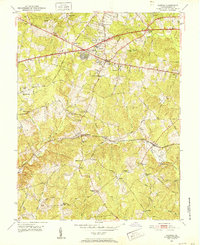 1951 Fairfax1952 Print · USGSFairfax and its surrounding crossroads are captured in the early fifties, before the arrival of the modern beltway and suburban sprawl. Researchers can trace historic family landmarks and local institutions like Fairfax Station, Jerusalem Ch, and Makleys Store.
 - 1955 Map of Fairfax, 1958 Print
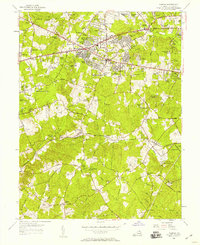 1955 Fairfax1958 Print · USGSFairfax County was transitioning from rural acreage to post-war suburbs during the mid-fifties as major roads like the Little River Turnpike expanded. Researchers can trace the roots of modern neighborhoods alongside older sites like Robeys Mill, the Southern railway stops, and the State Prison Camp.2 unique versions available
 - 1957 Map of Washington, 1966 Print
 1957 Washington1966 Print · USGSThe mid-Atlantic region during the mid-fifties and early sixties reveals a landscape of growing suburbs and vital military outposts. Researchers can trace historic river towns and shorelines from Alexandria to the Hooper Islands and St Clements Island.5 unique versions available
End of results
Showing maps 1-3 of 3
Top cities near Mantua
- Washington historical maps
- Arlington historical maps
- Alexandria historical maps
- Dale City historical maps
- Silver Spring historical maps
- Centreville historical maps
See more
Frequently asked questions
- What are the different types of historical maps available for Mantua?
- What is the oldest map of Mantua?
- Where can I purchase historical maps of Mantua for my home or office?
- Where can I download high-res historical maps of Mantua?
- Are there historical topographic maps available for Mantua?
- Is there historical aerial imagery available for Mantua?
- Where are historical maps of Mantua sourced from?