1940s Maps of Mount Vernon, Virginia
Explore 4 historic maps of Mount Vernon from the 1940s. These maps offer a rare glimpse into what life looked like during the 1940s — showing old roads, neighborhoods, homes, and landmarks that have changed or disappeared over time.
Whether you're researching your family's past, planning a metal detecting trip, or studying how Mount Vernon's landscape evolved across the 1940s, these high-resolution maps are a powerful tool for exploring the history of this region.
- Focus on a specific era: All maps on this page are from the 1940s, giving you a focused view of this time period.
- See what’s changed: Compare century-old streets, trails, and buildings to today's modern landscape using overlays and satellite layers.
- Research with precision: Use these maps for genealogy, historical research, land use analysis, or educational projects.
- View, download, or print: Maps are fully viewable online in high resolution, and can be downloaded or printed for your own records.
Start exploring Mount Vernon's history through authentic maps from the 1940s. This is your window into the past.
Mount Vernon, VA maps
(4)- 1944 Map of Belvoir
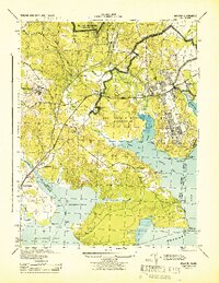 1944 Belvoir1944 Print · USGSFairfax County is shown at a pivotal moment in the 1940s, balancing its historic riverfront estates with wartime military expansion. Genealogists can trace old family sites and stations near Woodbridge, Colchester, and the landmark Gunston Hall.
 - 1944 Map of Mount Vernon
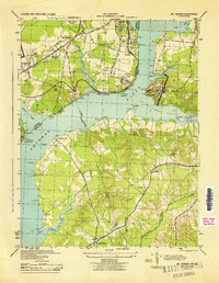 1944 Mount Vernon1944 Print · USGSThe Potomac River shoreline during the Second World War reveals a landscape of coastal fortifications and early aviation. Genealogists and historians can trace old community hubs like Gum Springs, Accokeek, and the historic Marshall Hall estate.
 - 1948 Map of Washington
 1948 Washington1948 Print · USGSThe Potomac and Chesapeake regions in the late 1940s reveal a landscape of expanding military reach and deep-rooted Tidewater settlements. Trace old rail corridors like the Richmond Fredericksburg & Potomac RR or locate landmarks like the Wakefield Washington Monument and St. Marys College.2 unique versions available
 - 1948 Map of Belvoir
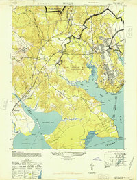 1948 Belvoir1948 Print · USGSFairfax County and the Potomac River shoreline appear in the late 1940s as military expansion meets historic Virginia estates. Trace the footprint of Fort Belvoir and search for family roots near Gunston Hall, Pohick Ch, and the old settlement at Colchester.
End of results
Showing maps 1-4 of 4
Top cities near Mount Vernon
- Washington historical maps
- Arlington historical maps
- Alexandria historical maps
- Waldorf historical maps
- Bethesda historical maps
- McLean historical maps
See more
Top neighborhoods of Mount Vernon
- Woodlawn historical maps
- Woodley Hills historical maps
- Engleside historical maps
- Waldon Woods historical maps
- Sequoyah historical maps
- Southwood historical maps
See more
Frequently asked questions
- What are the different types of historical maps available for Mount Vernon?
- What is the oldest map of Mount Vernon?
- Where can I purchase historical maps of Mount Vernon for my home or office?
- Where can I download high-res historical maps of Mount Vernon?
- Are there historical topographic maps available for Mount Vernon?
- Is there historical aerial imagery available for Mount Vernon?
- Where are historical maps of Mount Vernon sourced from?