1900s (20th Century) Maps of Linden, Virginia
Explore 10 historic maps of Linden from the 1900s (20th Century). These maps offer a rare glimpse into what life looked like during the 1900s — showing old roads, neighborhoods, homes, and landmarks that have changed or disappeared over time.
Whether you're researching your family's past, planning a metal detecting trip, or studying how Linden's landscape evolved across the 1900s, these high-resolution maps are a powerful tool for exploring the history of this region.
- Focus on a specific era: All maps on this page are from the 1900s, giving you a focused view of this time period.
- See what’s changed: Compare century-old streets, trails, and buildings to today's modern landscape using overlays and satellite layers.
- Research with precision: Use these maps for genealogy, historical research, land use analysis, or educational projects.
- View, download, or print: Maps are fully viewable online in high resolution, and can be downloaded or printed for your own records.
Start exploring Linden's history through authentic maps from the 1900s. This is your window into the past.
Linden, VA maps
(10)- 1905 Map of Luray, 1910 Print
 1905 Luray1910 Print · USGSThe Blue Ridge and Shenandoah Valley are frozen in time just after the turn of the century, showing the critical rail networks and mountain gaps of the period. Genealogists can trace family names and settlements like Luray, Front Royal, and Strasburg along the Shenandoah Valley Railroad.4 unique versions available
 - 1939 Map of Front Royal
 1939 Front Royal1939 Print · USGSThe Blue Ridge foothills and Front Royal are shown here during the late 1930s as the national park and military reservations were being established. Genealogists and historians can trace family locations through numerous rural institutions like Mt Paran Ch, Lottie Sch, and Miller Cem.2 unique versions available
 - 1944 Map of Front Royal
 1944 Front Royal1944 Print · USGSFront Royal and the northern Blue Ridge Mountains appear here during the mid-forties as industrial growth and federal land projects reshaped the valley. Researchers can trace family sites like Miller Cem, explore the early Skyline Drive, and locate schools such as Harmony Hollow Sch.2 unique versions available
 - 1949 Map of Charlottesville
 1949 Charlottesville1949 Print · USGSThe Shenandoah Valley and Blue Ridge appear in the late 1940s as a thriving corridor of rail and river commerce. Researchers can trace the mid-century footprints of Harrisonburg, Staunton, and Culpeper alongside the historic routes of the Southern Railway.2 unique versions available
 - 1956 Map of Charlottesville, 1966 Print
 1956 Charlottesville1966 Print · USGSThe Shenandoah Valley and Blue Ridge are captured in detail during the mid-1960s as the modern interstate system began to emerge. Genealogists and historians can trace rail-connected hubs like Waynesboro or follow the river paths of the Rapidan River and Rivanna River.4 unique versions available
 - 1966 Map of Linden, 1968 Print
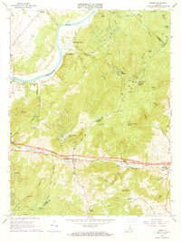 1966 Linden1968 Print · USGSThe Blue Ridge mountain passes of Warren and Fauquier counties are captured here in the mid-1960s. Genealogists and hikers can trace the Appalachian Trail across Blue Mountain or locate old community centers like Linden, Markham, and Mt Paran Ch.5 unique versions available
 - 1972 Map of Linden, 1977 Print
 1972 Linden1977 Print · USGSThe Blue Ridge foothills and Shenandoah Valley are revealed in this 1970s orthophotograph, capturing the area's rural character during a period of transition. Genealogists and local researchers can trace property lines and roads around Linden, Markham, and the Shenandoah River.
 - 1986 Map of Front Royal
 1986 Front Royal1986 Print · USGSThe northern Shenandoah Valley and the Blue Ridge crest are captured here in the mid-eighties as modern highways began to bypass historic valley towns. Researchers can trace ancestral connections near Peola Mills, navigate the gaps like Manassas Gap, or study the river bends around Luray.3 unique versions available
 - 1986 Map of Linden, 1987 Print
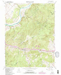 1986 Linden1987 Print · USGSWarren and Fauquier counties are captured here in the mid-eighties as the railway and mountain passes continue to shape life in the Blue Ridge. Trace the historic route of the Southern railroad through Manassas Gap or locate family roots near Mt Paran Ch and Howellsville.
 - 1994 Map of Linden, 1997 Print
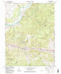 1994 Linden1997 Print · USGSThe Blue Ridge mountain gaps and river bends are captured here in the mid-1990s, during a time of both conservation and residential growth. Genealogists and hikers can trace the Appalachian Trail past the Mosby Shelter and locate old crossroads like Linden, Markham, and Howellsville.
End of results
Showing maps 1-10 of 10
Top cities near Linden
- Front Royal historical maps
- Shenandoah Farms historical maps
- Marshall historical maps
- Stephens City historical maps
- Middletown historical maps
- Apple Mountain Lake historical maps
See more
Frequently asked questions
- What are the different types of historical maps available for Linden?
- What is the oldest map of Linden?
- Where can I purchase historical maps of Linden for my home or office?
- Where can I download high-res historical maps of Linden?
- Are there historical topographic maps available for Linden?
- Is there historical aerial imagery available for Linden?
- Where are historical maps of Linden sourced from?