1960s Maps of Ashland, Virginia
Explore 4 historic maps of Ashland from the 1960s. These maps offer a rare glimpse into what life looked like during the 1960s — showing old roads, neighborhoods, homes, and landmarks that have changed or disappeared over time.
Whether you're researching your family's past, planning a metal detecting trip, or studying how Ashland's landscape evolved across the 1960s, these high-resolution maps are a powerful tool for exploring the history of this region.
- Focus on a specific era: All maps on this page are from the 1960s, giving you a focused view of this time period.
- See what’s changed: Compare century-old streets, trails, and buildings to today's modern landscape using overlays and satellite layers.
- Research with precision: Use these maps for genealogy, historical research, land use analysis, or educational projects.
- View, download, or print: Maps are fully viewable online in high resolution, and can be downloaded or printed for your own records.
Start exploring Ashland's history through authentic maps from the 1960s. This is your window into the past.
Ashland, VA maps
(4)- 1963 Map of Yellow Tavern, 1965 Print
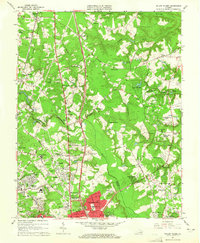 1963 Yellow Tavern1965 Print · USGSNorth of Richmond in the early sixties, the Hanover and Henrico borderlands remained a landscape of historic landmarks and growing suburbs. Genealogists and historians can locate family-named sites like Heaths Store, the Henry Clay Birthplace, and the JEB Stuart Monument.6 unique versions available
 - 1964 Map of Richmond
 1964 Richmond1964 Print · USGSCoastal and central Virginia are mapped during the mid-twentieth century, showing the critical intersection of rail, river, and military life. Genealogists can trace family roots through rural county seats like Amelia or find vanished coastal neighborhoods near Phoebus and Hilton Village.
 - 1969 Map of Ashland, 1970 Print
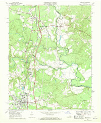 1969 Ashland1970 Print · USGSHanover County in the late sixties shows the growth of Ashland around Randolph-Macon College and its dual-railroad corridors. Genealogists can trace family names at Mt Hope Ch or locate old community hubs like Gum Tree and Ashland Mill.4 unique versions available
 - 1969 Map of Hanover Academy, 1970 Print
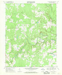 1969 Hanover Academy1970 Print · USGSHanover County at the end of the 1960s shows a landscape of river-bend settlements and rural crossroads. Local historians can trace family-named landmarks and old congregations like Scotchtown, Independence Ch, and the Fork Ch Cem.4 unique versions available
End of results
Showing maps 1-4 of 4
Top cities near Ashland
- Richmond historical maps
- Tuckahoe historical maps
- Mechanicsville historical maps
- Short Pump historical maps
- Highland Springs historical maps
- Glen Allen historical maps
See more
Top neighborhoods of Ashland
Frequently asked questions
- What are the different types of historical maps available for Ashland?
- What is the oldest map of Ashland?
- Where can I purchase historical maps of Ashland for my home or office?
- Where can I download high-res historical maps of Ashland?
- Are there historical topographic maps available for Ashland?
- Is there historical aerial imagery available for Ashland?
- Where are historical maps of Ashland sourced from?