1930s Maps of Henrico County, Virginia
Explore 9 historic maps of Henrico County from the 1930s. These maps offer a rare glimpse into what life looked like during the 1930s — showing old roads, neighborhoods, homes, and landmarks that have changed or disappeared over time.
Whether you're researching your family's past, planning a metal detecting trip, or studying how Henrico County's landscape evolved across the 1930s, these high-resolution maps are a powerful tool for exploring the history of this region.
- Focus on a specific era: All maps on this page are from the 1930s, giving you a focused view of this time period.
- See what’s changed: Compare century-old streets, trails, and buildings to today's modern landscape using overlays and satellite layers.
- Research with precision: Use these maps for genealogy, historical research, land use analysis, or educational projects.
- View, download, or print: Maps are fully viewable online in high resolution, and can be downloaded or printed for your own records.
Start exploring Henrico County's history through authentic maps from the 1930s. This is your window into the past.
Henrico County, VA maps
(9)- 1934 Map of Seven Pines
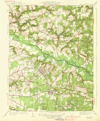
 1934 Seven Pines1934 Print · USGSHenrico and Hanover counties are seen here in the mid-1930s, documenting a landscape where historic battlegrounds met the dawn of modern aviation. Researchers can trace the legacy of local conflict through the National Cem or locate community centers like New Bridge Ch and Highland Springs.
 - 1934 Map of Richmond
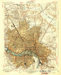
 1934 Richmond1934 Print · USGSRichmond's urban landscape is captured in the mid-1930s, showing a capital city shaped by its riverfront industry and rail network. Researchers can trace the grounds of the State Capitol, find the Broad Street Sta, and locate the Confederate Soldiers Home.2 unique versions available
 - 1936 Map of Richmond West
 1936 Richmond West1936 Print · USGSThe James River corridor west of Richmond was rapidly evolving in the mid-1930s as suburban life and industry converged. Genealogists and historians can trace the foundations of Windsor Farms, the University of Richmond, and rural landmarks like Camack Mill and Bon Air.2 unique versions available
 - 1936 Map of Glen Allen
 1936 Glen Allen1936 Print · USGSHenrico and Hanover counties are captured here in the mid-1930s, showing a rural landscape organized around the Chickahominy River. Genealogists and local historians can trace the foundations of Short Pump, find Deep Run Ch, or locate the Richmond Fredericksburg and Potomac Railroad corridor.2 unique versions available
 - 1938 Map of Dutch Gap
 1938 Dutch Gap1938 Print · USGSHenrico County and the James River loops are seen here in the late thirties, when military breastworks still crisscrossed the rural landscape. Researchers can locate Richmond National Battlefield Park and ancestral sites like Montague Cem and the Union Grove Chapel.
 - 1938 Map of Seven Pines
 1938 Seven Pines1938 Print · USGSEastern Henrico County and Hanover County are seen here in the mid-1930s as suburban growth began to meet rural history. Genealogists and historians can trace family landmarks like the Trent House, find rural schools such as Dry Bridge Sch, and locate the early Richard E Byrd Landing Field.3 unique versions available
 - 1938 Map of Drewrys Bluff
 1938 Drewrys Bluff1938 Print · USGSThe James River corridor south of Richmond is seen here just before the Second World War, showing a landscape still defined by its defensive past. Genealogists can trace family names and sites like Bensley Village, Ebenezer Ch, and numerous Civil War-era Breastworks.
 - 1938 Map of Yellow Tavern
 1938 Yellow Tavern1938 Print · USGSHanover and Henrico counties appear in the 1930s as a landscape of rural crossroads and river bottomlands. Genealogists can trace family-named landmarks and institutions like the Henry Clay Birthplace, St Josephs Villa, and the Jeb Stuart Monument.3 unique versions available
 - 1939 Map of Richmond
 1939 Richmond1939 Print · USGSRichmond before the war shows a sophisticated urban landscape defined by river power and a complex rail network. Genealogists and historians can locate numerous burial grounds like Hollywood Cemetery or trace the early streetcar path of the Richmond Ashland Electric Ry.2 unique versions available
End of results
Showing maps 1-9 of 9
Top cities of Henrico County
- Tuckahoe historical maps
- Short Pump historical maps
- Highland Springs historical maps
- Glen Allen historical maps
- Lakeside historical maps
- Dumbarton historical maps
See more
Frequently asked questions
- What are the different types of historical maps available for Henrico County?
- What is the oldest map of Henrico County?
- Where can I purchase historical maps of Henrico County for my home or office?
- Where can I download high-res historical maps of Henrico County?
- Are there historical topographic maps available for Henrico County?
- Is there historical aerial imagery available for Henrico County?
- Where are historical maps of Henrico County sourced from?