1950s Maps of Henrico County, Virginia
Explore 9 historic maps of Henrico County from the 1950s. These maps offer a rare glimpse into what life looked like during the 1950s — showing old roads, neighborhoods, homes, and landmarks that have changed or disappeared over time.
Whether you're researching your family's past, planning a metal detecting trip, or studying how Henrico County's landscape evolved across the 1950s, these high-resolution maps are a powerful tool for exploring the history of this region.
- Focus on a specific era: All maps on this page are from the 1950s, giving you a focused view of this time period.
- See what’s changed: Compare century-old streets, trails, and buildings to today's modern landscape using overlays and satellite layers.
- Research with precision: Use these maps for genealogy, historical research, land use analysis, or educational projects.
- View, download, or print: Maps are fully viewable online in high resolution, and can be downloaded or printed for your own records.
Start exploring Henrico County's history through authentic maps from the 1950s. This is your window into the past.
Henrico County, VA maps
(9)- 1951 Map of Yellow Tavern
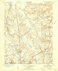 1951 Yellow Tavern1951 Print · USGSNorth of Richmond in the early fifties, this area reveals a landscape of rural stores and historic memorials along the Chickahominy. Trace the sites of the Henry Clay Birthplace, the Jeb Stuart Monument, and the rail junction at Atlee Sta.
 - 1952 Map of Drewrys Bluff, 1959 Print
 1952 Drewrys Bluff1959 Print · USGSChesterfield County and the James River corridor are captured here in the 1950s as suburban growth and highway expansion begin to meet historic defense lines. Trace the local landscape through the Richmond Quatermaster Depot, Parnell Airport, and Antioch Ch.
 - 1952 Map of Hopewell, 1959 Print
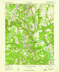
 1952 Hopewell1959 Print · USGSThe industrial hub of Hopewell and the grounds of Fort Lee are captured here during the early fifties. Researchers can trace the heritage of the James River through landmarks like Bermuda Hundred, Walthall Mill, and the historic City Point waterfront.
 - 1952 Map of Dutch Gap, 1959 Print
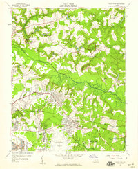
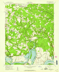 1952 Dutch Gap1959 Print · USGSHenrico County in the early fifties remains a landscape of river plantations and Civil War battlements along the James River. Genealogists and historians can trace family sites at Varina Plantation, find Second Bethel Ch, or locate markers within the National Cem and Richmond National Battlefield Park.
 - 1953 Map of Roxbury, 1957 Print
 1953 Roxbury1957 Print · USGSCharles City and Henrico counties appear here in the early fifties, documenting a landscape of riverfront plantations and inland crossroads. Researchers can trace rural landmarks like the Samaria Indian Sch, the National Cem, and family sites like Hughes Store.
 - 1953 Map of Charles City, 1960 Print
 1953 Charles City1960 Print · USGSCoastal Virginia during the mid-fifties reveals a landscape defined by historic James River plantations and rural crossroads. Genealogists and historians can trace family-named sites from Berkeley and Westover to local landmarks like Ednas Mill and Merchant Hope Ch.2 unique versions available
 - 1956 Map of Seven Pines, 1959 Print
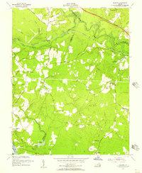
 1956 Seven Pines1959 Print · USGSEast of Richmond in the mid-fifties, the landscape reveals a layering of significant Civil War sites and burgeoning mid-century suburban expansion. Researchers can trace historic landmarks like the Garthright House, several old mills including Gaines Mill, and the grounds of Savage Station.
 - 1956 Map of Richmond, 1959 Print
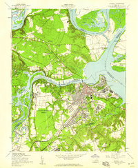
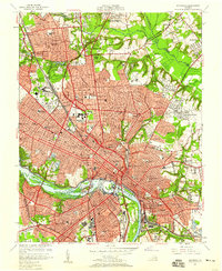 1956 Richmond1959 Print · USGSMid-century Richmond is shown just as the new turnpike began to reshape the urban landscape and the historic James River riverfront. Researchers can trace the footprints of Union Theological Seminary, the historic Hollywood Cemetery, and the old Seaboard Air Line Railroad yards.
 - 1959 Map of Richmond
 1959 Richmond1959 Print · USGSMid-century Virginia is captured here at its most vital rail and river junctions, from the capital city to the Chesapeake Bay. Genealogists and historians can trace the development of colonial settlements like Williamsburg and military landmarks including Fort Monroe and Camp Lee.
End of results
Showing maps 1-9 of 9
Top cities of Henrico County
- Tuckahoe historical maps
- Short Pump historical maps
- Highland Springs historical maps
- Glen Allen historical maps
- Lakeside historical maps
- Dumbarton historical maps
See more
Frequently asked questions
- What are the different types of historical maps available for Henrico County?
- What is the oldest map of Henrico County?
- Where can I purchase historical maps of Henrico County for my home or office?
- Where can I download high-res historical maps of Henrico County?
- Are there historical topographic maps available for Henrico County?
- Is there historical aerial imagery available for Henrico County?
- Where are historical maps of Henrico County sourced from?