1940s Maps of Foursquare, Virginia
Explore 2 historic maps of Foursquare from the 1940s. These maps offer a rare glimpse into what life looked like during the 1940s — showing old roads, neighborhoods, homes, and landmarks that have changed or disappeared over time.
Whether you're researching your family's past, planning a metal detecting trip, or studying how Foursquare's landscape evolved across the 1940s, these high-resolution maps are a powerful tool for exploring the history of this region.
- Focus on a specific era: All maps on this page are from the 1940s, giving you a focused view of this time period.
- See what’s changed: Compare century-old streets, trails, and buildings to today's modern landscape using overlays and satellite layers.
- Research with precision: Use these maps for genealogy, historical research, land use analysis, or educational projects.
- View, download, or print: Maps are fully viewable online in high resolution, and can be downloaded or printed for your own records.
Start exploring Foursquare's history through authentic maps from the 1940s. This is your window into the past.
Foursquare, VA maps
(2)- 1944 Map of Smithfield, 1961 Print
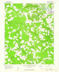 1944 Smithfield1961 Print · USGSCoastal Virginia during the mid-forties reveals a landscape of tidal rivers and rural crossroads. Genealogists and historians can trace old homesteads near Central Hill, numerous country chapels like Ebenezer Ch, and the defunct Old Railroad Grade.
 - 1945 Map of Smithfield
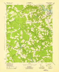 1945 Smithfield1945 Print · USGSCoastal Virginia during the mid-forties reveals a landscape of tidal rivers and rural townships centered around the Pagan River. Genealogists and historians can locate family landmarks such as Four Square, the Isle of Wight Courthouse, and the Trinity Sch.
End of results
Showing maps 1-2 of 2
Top cities near Foursquare
- Smithfield historical maps
- Carrollton historical maps
- Windsor historical maps
- Benns Church historical maps
- Rushmere historical maps
- Ivor historical maps
See more
Frequently asked questions
- What are the different types of historical maps available for Foursquare?
- What is the oldest map of Foursquare?
- Where can I purchase historical maps of Foursquare for my home or office?
- Where can I download high-res historical maps of Foursquare?
- Are there historical topographic maps available for Foursquare?
- Is there historical aerial imagery available for Foursquare?
- Where are historical maps of Foursquare sourced from?