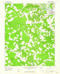
1944 Map of Smithfield
USGS Topo · Published 1961About this map
Pagan River tidewaters frame the historic town of Smithfield, shown here as it transitioned through the mid-1940s. The landscape is defined by its characteristic Tidewater drainage, where numerous swamps like Comet Swamp and Rattlesnake Swamp feed into larger creeks and ponds. Evidence of changing transportation and communication is clear, with an Old Railroad Grade cutting through the western portion of the county and an early Underground Telephone line crossing the center. The map reveals a deeply rooted rural community, marked by a high density of country churches such as Pentecostal Ch, Bethlehem Ch, and Bethel Ch. Local education is anchored by the Isle of Wight Sch and Trinity Sch, while small crossroads like Central Hill and Magnet served as focal points for the surrounding agricultural tracts and timbered lands of the Ross Pocosin.
Find a feature on this map
33 named features on this map. Tap any name to fly to it.
Don’t see what you’re looking for? This feature index may not catch every label — zoom into the map to look around manually.
Map Details
Editions of this 1944 Smithfield Map
This is the sole edition of this map. No revisions or reprints were ever made.
Other maps of this area

1907 · Yorktown
USGS Topo · 1:62,500

1919 · Smithfield
USGS Topo · 1:62,500

1919 · Surry
USGS Topo · 1:62,500

1920 · Ivor
USGS Topo · 1:62,500

1943 · Yorktown
USGS Topo · 1:62,500

1943 · Richmond
USGS Topo · 1:250,000
1944 · Windsor
USGS Topo · 1:31,680

1944 · Raynor
USGS Topo · 1:24,000

1944 · Zuni
USGS Topo · 1:24,000

1945 · Zuni
USGS Topo · 1:31,680