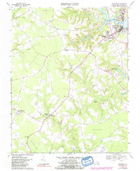
1968 Map of Smithfield
USGS Topo · Published 1991About this map
Smithfield sits at the confluence of the Pagan River and several tidal creeks, serving as a focal point for this Virginia coastal plain landscape. The geography is defined by an extensive network of low-lying wetlands, including Comet Swamp, Rattlesnake Swamp, and the large Great Swamp to the south. These watercourses were historically critical for industry and transit, evidenced by the Courthouse Millpond and the presence of the Old Railroad Grade cutting across the southwestern quadrant.
Find a feature on this map
36 named features on this map. Tap any name to fly to it.
Don’t see what you’re looking for? This feature index may not catch every label — zoom into the map to look around manually.
Map Details
Editions of this 1968 Smithfield Map
4 editions found
Other maps of this area

1907 · Yorktown
USGS Topo · 1:62,500

1919 · Smithfield
USGS Topo · 1:62,500

1919 · Surry
USGS Topo · 1:62,500

1920 · Ivor
USGS Topo · 1:62,500

1943 · Yorktown
USGS Topo · 1:62,500

1943 · Richmond
USGS Topo · 1:250,000

1944 · Windsor
USGS Topo · 1:31,680

1944 · Smithfield
USGS Topo · 1:24,000

1944 · Raynor
USGS Topo · 1:24,000

1944 · Zuni
USGS Topo · 1:24,000