
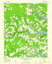
1944 Map of Windsor
USGS Topo · Published 1944About this map
The Norfolk and Western railway corridor defines the agricultural and timbered landscape of this Tidewater region during the mid-1940s. Centered on the town of Windsor, the map details a community deeply connected by rail and water, where local industry is marked by numerous millponds such as Murphys Millpond and Prudens Millpond. The transition from rural Isle of Wight County into Nansemond County is documented through a network of early roads like Courthouse Rd and Exchange Road, connecting scattered farmsteads and rural institutions.
Find a feature on this map
45 named features on this map. Tap any name to fly to it.
Don’t see what you’re looking for? This feature index may not catch every label — zoom into the map to look around manually.
Map Details
Editions of this 1944 Windsor Map
2 editions found
Other maps of this area

1919 · Smithfield
USGS Topo · 1:62,500

1919 · Suffolk
USGS Topo · 1:62,500

1920 · Holland
USGS Topo · 1:62,500

1920 · Ivor
USGS Topo · 1:62,500

1943 · Holland
USGS Topo · 1:62,500

1944 · Smithfield
USGS Topo · 1:24,000

1944 · Raynor
USGS Topo · 1:24,000

1944 · Zuni
USGS Topo · 1:24,000

1945 · Zuni
USGS Topo · 1:31,680
1945 · Raynor
USGS Topo · 1:31,680