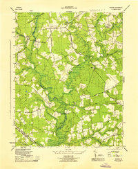
1945 Map of Raynor
USGS Topo · Published 1945About this map
Blackwater River snakes along the boundary between Surry, Southampton, and Isle of Wight counties, defining a landscape dominated by extensive wetland systems. The drainage network includes numerous named reaches such as Terrapin Swamp, Mill Swamp, and Rattlesnake Swamp, which separate clusters of small agricultural settlements and crossroads. The map documents the rural infrastructure of the mid-1940s, highlighting central community hubs like the Mill Swamp Ch and Cem and educational sites including McClelland Sch and Godwin Sch. Local transit at this time relied on a mix of established roads like Mcclelland Road and specialized routes such as the Racetrack RD. The southern portion of the quadrangle is anchored by the Norfolk and Western railroad corridor and the settlement of Tucker, while river crossings at Proctors Bridge and Broadwater Bridge provide critical links across the swampy bottomlands.
Find a feature on this map
38 named features on this map. Tap any name to fly to it.
Don’t see what you’re looking for? This feature index may not catch every label — zoom into the map to look around manually.
Map Details
Editions of this 1945 Raynor Map
This is the sole edition of this map. No revisions or reprints were ever made.
Other maps of this area

1907 · Yorktown
USGS Topo · 1:62,500

1919 · Smithfield
USGS Topo · 1:62,500

1919 · Surry
USGS Topo · 1:62,500

1920 · Ivor
USGS Topo · 1:62,500

1943 · Yorktown
USGS Topo · 1:62,500

1943 · Richmond
USGS Topo · 1:250,000

1944 · Windsor
USGS Topo · 1:31,680

1944 · Ivor
USGS Topo · 1:24,000

1944 · Smithfield
USGS Topo · 1:24,000

1944 · Sedley
USGS Topo · 1:24,000