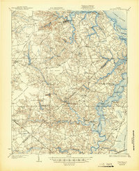
1919 Map of Smithfield
USGS Topo · Published 1944About this map
Smithfield and the surrounding Tidewater landscape are defined by the intricate waterways of the James River and Nansemond River just after the First World War. This survey illustrates a coastal economy transitioning from traditional river traffic to inland rail, with numerous wharves like Godwins Wharf and Whitley Wharf still serving the creeks while the Southern Railway and Virginian Railway cut through the southern lowlands. Local genealogy is well-supported by the density of named rural institutions, including Benns Church, St Johns Church, and the Garner School. The landscape transitions from the developed necks of land into the watery reaches of Ross Pocoson and the northern edge of the Dismal Swamp. The reliance on water power is evident in several inland features such as Prudens Mill and Branch and Jones Millpond, which reflect the early twentieth-century milling industry in Isle of Wight and Nansemond counties.
Find a feature on this map
109 named features on this map. Tap any name to fly to it.
Don’t see what you’re looking for? This feature index may not catch every label — zoom into the map to look around manually.
Map Details
Editions of this 1919 Smithfield Map
4 editions found
Other maps of this area

1907 · Norfolk
USGS Topo · 1:125,000

1907 · Yorktown
USGS Topo · 1:62,500

1907 · Hampton
USGS Topo · 1:62,500

1919 · Smithfield
USGS Topo · 1:62,500

1919 · Suffolk
USGS Topo · 1:62,500

1919 · Surry
USGS Topo · 1:62,500

1920 · Holland
USGS Topo · 1:62,500

1920 · Ivor
USGS Topo · 1:62,500

1921 · Newport News
USGS Topo · 1:62,500

1940 · Lake Drummond
USGS Topo · 1:62,500