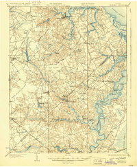
1919 Map of Smithfield
USGS Topo · Published 1929About this map
Smithfield and the surrounding Tidewater landscape define this 1918 survey, captured just before modern development transformed the Isle of Wight and Nansemond county border. The map reveals an economy deeply tied to the water, where the Nansemond River and Pagan Creek served as primary arteries for transit and trade. Numerous wharves, such as Whitley Wharf and Ferry Pt Wharf, underscore the importance of the river-and-rail network that connected rural settlements like Chuckatuck and Carrollton to the broader Chesapeake region.
Find a feature on this map
100 named features on this map. Tap any name to fly to it.
Don’t see what you’re looking for? This feature index may not catch every label — zoom into the map to look around manually.
Map Details
Editions of this 1919 Smithfield Map
4 editions found
Other maps of this area

1907 · Norfolk
USGS Topo · 1:125,000

1907 · Yorktown
USGS Topo · 1:62,500

1907 · Hampton
USGS Topo · 1:62,500

1919 · Smithfield
USGS Topo · 1:62,500

1919 · Suffolk
USGS Topo · 1:62,500

1919 · Surry
USGS Topo · 1:62,500

1920 · Holland
USGS Topo · 1:62,500

1920 · Ivor
USGS Topo · 1:62,500

1921 · Newport News
USGS Topo · 1:62,500

1940 · Lake Drummond
USGS Topo · 1:62,500