1960s Maps of Smithfield Historic District, Smithfield
Explore 2 historic maps of Smithfield Historic District from the 1960s. These maps offer a rare glimpse into what life looked like during the 1960s — showing old roads, neighborhoods, homes, and landmarks that have changed or disappeared over time.
Whether you're researching your family's past, planning a metal detecting trip, or studying how Smithfield Historic District's landscape evolved across the 1960s, these high-resolution maps are a powerful tool for exploring the history of this region.
- Focus on a specific era: All maps on this page are from the 1960s, giving you a focused view of this time period.
- See what’s changed: Compare century-old streets, trails, and buildings to today's modern landscape using overlays and satellite layers.
- Research with precision: Use these maps for genealogy, historical research, land use analysis, or educational projects.
- View, download, or print: Maps are fully viewable online in high resolution, and can be downloaded or printed for your own records.
Start exploring Smithfield Historic District's history through authentic maps from the 1960s. This is your window into the past.
Smithfield Historic District, Smithfield maps
(2)- 1965 Map of Benns Church, 1966 Print
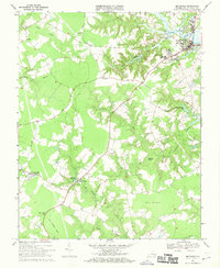
 1965 Benns Church1966 Print · USGSCoastal Isle of Wight County is captured here in the mid-sixties, showing a landscape of tidal creeks and historic riverfront villages. Genealogists and historians can trace local landmarks like St Lukes Ch (Old Brick Ch), the Battery Park Cem, and the rural crossroads at Wills Corner.7 unique versions available
 - 1968 Map of Smithfield, 1970 Print
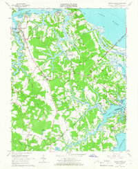
 1968 Smithfield1970 Print · USGSCoastal Virginia life in the late sixties centers on the Pagan River and the rural crossroads of Isle of Wight County. Genealogists can trace family landmarks like Ivy Hill Cem, several country churches, and the Old Railroad Grade.4 unique versions available
End of results
Showing maps 1-2 of 2
Frequently asked questions
- What are the different types of historical maps available for Smithfield Historic District?
- What is the oldest map of Smithfield Historic District?
- Where can I purchase historical maps of Smithfield Historic District for my home or office?
- Where can I download high-res historical maps of Smithfield Historic District?
- Are there historical topographic maps available for Smithfield Historic District?
- Is there historical aerial imagery available for Smithfield Historic District?
- Where are historical maps of Smithfield Historic District sourced from?