Old Maps of Smithfield Historic District, Smithfield for Academic Research
Study the evolution of Smithfield Historic District with 13 high-resolution historic maps. Whether you're teaching, researching, or modeling changes in land use, these maps provide essential visual documentation of urban, environmental, and geographic change.
- Analyze long-term change: Track patterns in development, transportation, and natural features.
- Ideal for environmental or urban studies: Support academic projects with primary historical map data.
- Use in the classroom or lab: Educators and researchers rely on these maps to bring historical context to life.
These maps are a powerful tool for teaching, research, and visualizing how Smithfield Historic District has changed over the decades.
Smithfield Historic District, Smithfield maps
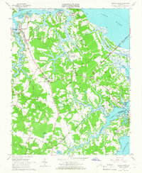
(13)- 1919 Map of Smithfield
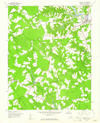
 1919 Smithfield1919 Print · USGSCoastal Virginia during the late teens was a world of steamboat routes and swamp-edge settlements. Genealogists can trace family roots through numerous local landmarks like St Johns Church, Whitley Wharf, and the rural community of Chuckatuck.4 unique versions available
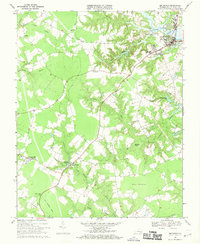
 - 1944 Map of Smithfield, 1961 Print
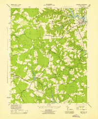
 1944 Smithfield1961 Print · USGSCoastal Virginia during the mid-forties reveals a landscape of tidal rivers and rural crossroads. Genealogists and historians can trace old homesteads near Central Hill, numerous country chapels like Ebenezer Ch, and the defunct Old Railroad Grade.
 - 1945 Map of Smithfield
 1945 Smithfield1945 Print · USGSCoastal Virginia during the mid-forties reveals a landscape of tidal rivers and rural townships centered around the Pagan River. Genealogists and historians can locate family landmarks such as Four Square, the Isle of Wight Courthouse, and the Trinity Sch.
 - 1950 Map of Blackstone
 1950 Blackstone1950 Print · USGSMid-century Blackstone is captured here as a major military hub during the post-war era. Genealogists and historians can locate legacy sites like Nottoway Training School, the Cemetery, and the sprawling Camp Pickett complex.
 - 1951 Map of Blackstone, 1958 Print
 1951 Blackstone1958 Print · USGSBlackstone and the surrounding Nottoway County landscape are seen here during the height of the Cold War military expansion. Genealogists and historians can trace the transition from town life at Spring Hill Church to the sprawling barracks and ranges of Camp Pickett.
 - 1952 Map of Benns Church
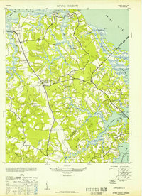 1952 Benns Church1952 Print · USGSCoastal Virginia during the mid-century was a landscape of tide-water marshes and bridge-linked communities. Genealogists can trace family names at The Old Brick Church, locate the Moonville Sch, and explore small settlements like Muddy Cross and Rescue.
 - 1953 Map of Norfolk, 1954 Print
 1953 Norfolk1954 Print · USGSCoastal Virginia and northeastern North Carolina appear here during the post-war industrial boom, showing the critical rail-and-sea connections of Hampton Roads. Genealogists can trace family roots through rural landmarks like Gethsemane Ch, the Caledonia State Prison Farm, and the vast interior of the Dismal Swamp.4 unique versions available
 - 1957 Map of Benns Church, 1960 Print
 1957 Benns Church1960 Print · USGSCoastal Isle of Wight County is shown here in the late fifties as a landscape of tidal marshes and rural crossroads. Genealogists and local historians can trace family locations near The Old Brick Ch, Muddy Cross, and the waterfront at Battery Park.
 - 1965 Map of Benns Church, 1966 Print
 1965 Benns Church1966 Print · USGSCoastal Isle of Wight County is captured here in the mid-sixties, showing a landscape of tidal creeks and historic riverfront villages. Genealogists and historians can trace local landmarks like St Lukes Ch (Old Brick Ch), the Battery Park Cem, and the rural crossroads at Wills Corner.7 unique versions available
 - 1968 Map of Smithfield, 1970 Print
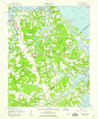
 1968 Smithfield1970 Print · USGSCoastal Virginia life in the late sixties centers on the Pagan River and the rural crossroads of Isle of Wight County. Genealogists can trace family landmarks like Ivy Hill Cem, several country churches, and the Old Railroad Grade.4 unique versions available
 - 1985 Map of Norfolk, 1986 Print
 1985 Norfolk1986 Print · USGSThe Tidewater region in the mid-eighties shows the dense urban expansion of the coastal cities alongside the preservation of the Great Dismal Swamp. Researchers can trace rural family-named crossroads and historic transit routes like the Seaboard Coast Line or find Somerton and Lake Drummond.3 unique versions available
 - 2022 Map of Benns Church, 2022 Print
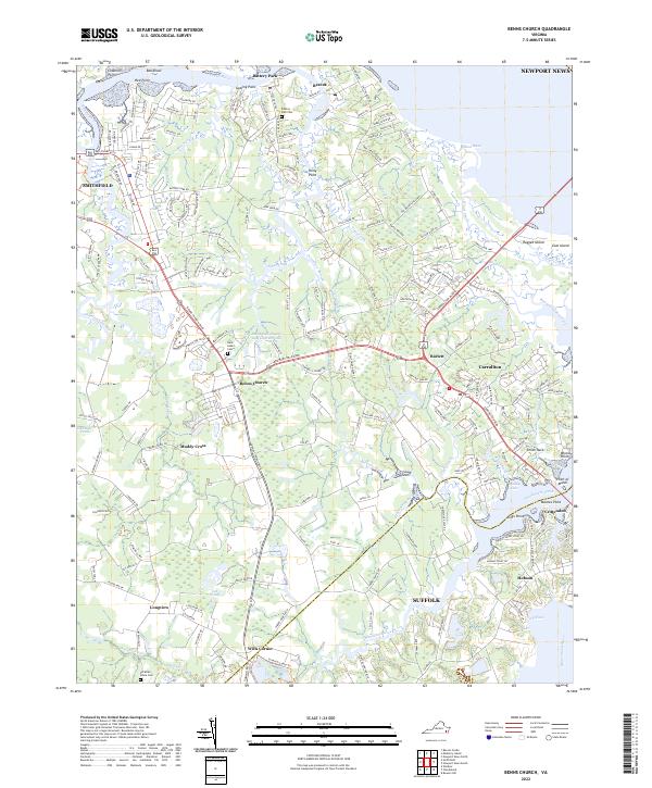 2022 Benns Church2022 Print · USGSCoastal Isle of Wight County comes into focus in this contemporary survey of the James River estuary. Genealogists and historians can locate family landmarks such as Saint Luke's Cem and trace the waterfront character of Battery Park and Crittenden.
 - 2022 Map of Smithfield, 2022 Print
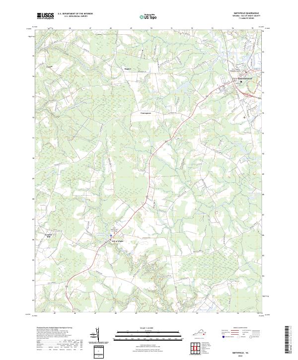 2022 Smithfield2022 Print · USGSCoastal Virginia’s landscape of wetlands and colonial-era settlements appears in detail here during the early twenty-first century. Researchers can trace the development of Smithfield and rural hamlets like Comet or locate the Isle of Wight County Courthouse.
End of results
Showing maps 1-13 of 13
Frequently asked questions
- What are the different types of historical maps available for Smithfield Historic District?
- What is the oldest map of Smithfield Historic District?
- Where can I purchase historical maps of Smithfield Historic District for my home or office?
- Where can I download high-res historical maps of Smithfield Historic District?
- Are there historical topographic maps available for Smithfield Historic District?
- Is there historical aerial imagery available for Smithfield Historic District?
- Where are historical maps of Smithfield Historic District sourced from?