1910s Maps of North Weems, Virginia
Explore 2 historic maps of North Weems from the 1910s. These maps offer a rare glimpse into what life looked like during the 1910s — showing old roads, neighborhoods, homes, and landmarks that have changed or disappeared over time.
Whether you're researching your family's past, planning a metal detecting trip, or studying how North Weems's landscape evolved across the 1910s, these high-resolution maps are a powerful tool for exploring the history of this region.
- Focus on a specific era: All maps on this page are from the 1910s, giving you a focused view of this time period.
- See what’s changed: Compare century-old streets, trails, and buildings to today's modern landscape using overlays and satellite layers.
- Research with precision: Use these maps for genealogy, historical research, land use analysis, or educational projects.
- View, download, or print: Maps are fully viewable online in high resolution, and can be downloaded or printed for your own records.
Start exploring North Weems's history through authentic maps from the 1910s. This is your window into the past.
North Weems, VA maps
(2)- 1916 Map of Kilmarnock
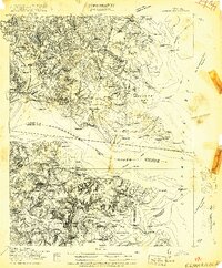 1916 Kilmarnock1916 Print · USGSBefore the era of modern bridges, this coastal Virginia region relied on a busy steamboat route network connecting the Northern Neck and Middle Peninsula. Genealogists can locate family landmarks like Wharton Grove Camp, White Chapel Church, and numerous landings including Morattico Wharf.2 unique versions available
 - 1917 Map of Kilmarnock
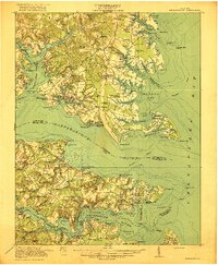 1917 Kilmarnock1917 Print · USGSThe Northern Neck and Middle Peninsula of Virginia are shown during the height of the steamboat era. Genealogists can locate family-named landmarks and essential community hubs like the Old Brick Church, Harmony Village, and Kilmarnock Wharf.4 unique versions available
End of results
Showing maps 1-2 of 2
Top cities near North Weems
- Kilmarnock historical maps
- Deltaville historical maps
- Irvington historical maps
- Saluda historical maps
- Hudgins historical maps
- Gwynn historical maps
See more
Frequently asked questions
- What are the different types of historical maps available for North Weems?
- What is the oldest map of North Weems?
- Where can I purchase historical maps of North Weems for my home or office?
- Where can I download high-res historical maps of North Weems?
- Are there historical topographic maps available for North Weems?
- Is there historical aerial imagery available for North Weems?
- Where are historical maps of North Weems sourced from?