1900s (20th Century) Maps of Dona, Virginia
Explore 9 historic maps of Dona from the 1900s (20th Century). These maps offer a rare glimpse into what life looked like during the 1900s — showing old roads, neighborhoods, homes, and landmarks that have changed or disappeared over time.
Whether you're researching your family's past, planning a metal detecting trip, or studying how Dona's landscape evolved across the 1900s, these high-resolution maps are a powerful tool for exploring the history of this region.
- Focus on a specific era: All maps on this page are from the 1900s, giving you a focused view of this time period.
- See what’s changed: Compare century-old streets, trails, and buildings to today's modern landscape using overlays and satellite layers.
- Research with precision: Use these maps for genealogy, historical research, land use analysis, or educational projects.
- View, download, or print: Maps are fully viewable online in high resolution, and can be downloaded or printed for your own records.
Start exploring Dona's history through authentic maps from the 1900s. This is your window into the past.
Dona, VA maps
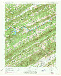
(9)- 1935 Map of Looneys Gap
 1935 Looneys Gap1935 Print · USGSNortheast Tennessee and Southwest Virginia are captured here in the mid-1930s, showing a landscape of river-bottom farms and ridge-top gaps. Researchers can locate vanished landmarks like Donald Mill, Tignors Ford, and the old Snow Flake settlement.
 - 1947 Map of Looneys Gap, 1970 Print
 1947 Looneys Gap1970 Print · USGSThe Clinch River valley in the late 1940s and late 1960s reveals a landscape of isolated ridge-and-valley settlements straddling the Virginia and Tennessee border. Researchers can trace ancestral locations at the County Farm, the Wake Forest School, and family plots like Sizemore Cem.
 - 1950 Map of Looneys Gap
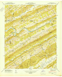 1950 Looneys Gap1950 Print · USGSThe Tennessee-Virginia borderlands in the 1940s are characterized by the steep ridges of Clinch Mountain and the deep bends of the Clinch River. Researchers can trace old mountain life through family sites like Sizemore Cem and rural schools like Wake Forest School.
 - 1955 Map of Johnson City
 1955 Johnson City1955 Print · USGSEast Tennessee and the bordering highlands of Virginia and Kentucky appear here during the post-war industrial boom. You can trace the complex network of mountain ridges and new TVA lakes, from Johnson City to the coalfields near Middlesboro and Lynch.
 - 1957 Map of Johnson City, 1966 Print
 1957 Johnson City1966 Print · USGSUpper East Tennessee and Southwest Virginia are shown here during the mid-sixties transition of the Appalachians. Researchers can trace the industrial rail hubs of Kingsport, the sprawling waters of Cherokee Lake, and the historic Cumberland Gap.
 - 1960 Map of Johnson City
 1960 Johnson City1960 Print · USGSUpper East Tennessee and the surrounding tri-state area are shown in the mid-fifties during the height of the TVA reservoir era. Trace the industrial rail lines of the Southern and Louisville and Nashville between Kingsport and Johnson City.
 - 1963 Map of Johnson City
 1963 Johnson City1963 Print · USGSThe Tri-Cities and the surrounding Appalachian ridges are shown in detail during the early sixties, highlighting the era's vital rail and river networks. Genealogists and historians can trace the routes of the Clinchfield RR and locate settlements from Rogersville to Elizabethton.
 - 1976 Map of Looneys Gap, 1981 Print
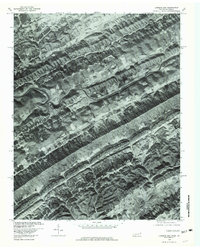 1976 Looneys Gap1981 Print · USGSHawkins County, Tennessee and neighboring Virginia appear in sharp photographic detail in the mid-seventies. Researchers can trace the layout of rural communities like Dona and Snow Flake or locate family sites near Looneys Gap.
 - 1981 Map of Bristol
 1981 Bristol1981 Print · USGSAppalachia and the Tri-Cities region are shown at a peak of industrial and rail development in the early eighties. Researchers can trace the Clinchfield Railroad through the mountains or find local landmarks like King College and the Holston Army Ammunition Plant.2 unique versions available
End of results
Showing maps 1-9 of 9
Top cities near Dona
- Church Hill historical maps
- Rogersville historical maps
- Pennington Gap historical maps
- Surgoinsville historical maps
- Sneedville historical maps
- Dryden historical maps
See more
Frequently asked questions
- What are the different types of historical maps available for Dona?
- What is the oldest map of Dona?
- Where can I purchase historical maps of Dona for my home or office?
- Where can I download high-res historical maps of Dona?
- Are there historical topographic maps available for Dona?
- Is there historical aerial imagery available for Dona?
- Where are historical maps of Dona sourced from?