1940s Maps of Kesterson Mill, Virginia
Explore 2 historic maps of Kesterson Mill from the 1940s. These maps offer a rare glimpse into what life looked like during the 1940s — showing old roads, neighborhoods, homes, and landmarks that have changed or disappeared over time.
Whether you're researching your family's past, planning a metal detecting trip, or studying how Kesterson Mill's landscape evolved across the 1940s, these high-resolution maps are a powerful tool for exploring the history of this region.
- Focus on a specific era: All maps on this page are from the 1940s, giving you a focused view of this time period.
- See what’s changed: Compare century-old streets, trails, and buildings to today's modern landscape using overlays and satellite layers.
- Research with precision: Use these maps for genealogy, historical research, land use analysis, or educational projects.
- View, download, or print: Maps are fully viewable online in high resolution, and can be downloaded or printed for your own records.
Start exploring Kesterson Mill's history through authentic maps from the 1940s. This is your window into the past.
Kesterson Mill, VA maps
(2)- 1946 Map of Ewing, 1962 Print
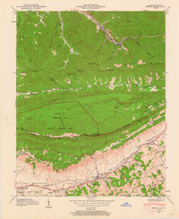 1946 Ewing1962 Print · USGSThe tri-state border country of Virginia and Kentucky comes alive here in the mid-1940s as the Cumberland Gap National Historical Park is established. Trace local family history through Ball Cem and Richmond Cem, or locate long-standing landmarks like Kesterson Mill and Chattels Station Ch.6 unique versions available
 - 1949 Map of Ewing
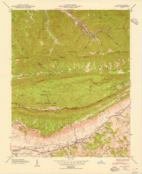 1949 Ewing1949 Print · USGSThe Kentucky and Virginia borderlands come to life in this mid-century survey of the Cumberland Gap region. Researchers can trace ancestral roots through dozens of family cemeteries like Richmond Cem or locate old industrial sites such as Cowan Mill and the County Industrial Sch.2 unique versions available
End of results
Showing maps 1-2 of 2
Top cities near Kesterson Mill
- Middlesboro historical maps
- Harrogate historical maps
- New Tazewell historical maps
- Tazewell historical maps
- Pineville historical maps
- Harlan historical maps
See more
Frequently asked questions
- What are the different types of historical maps available for Kesterson Mill?
- What is the oldest map of Kesterson Mill?
- Where can I purchase historical maps of Kesterson Mill for my home or office?
- Where can I download high-res historical maps of Kesterson Mill?
- Are there historical topographic maps available for Kesterson Mill?
- Is there historical aerial imagery available for Kesterson Mill?
- Where are historical maps of Kesterson Mill sourced from?