1940s Maps of Mineral, Virginia
Explore 6 historic maps of Mineral from the 1940s. These maps offer a rare glimpse into what life looked like during the 1940s — showing old roads, neighborhoods, homes, and landmarks that have changed or disappeared over time.
Whether you're researching your family's past, planning a metal detecting trip, or studying how Mineral's landscape evolved across the 1940s, these high-resolution maps are a powerful tool for exploring the history of this region.
- Focus on a specific era: All maps on this page are from the 1940s, giving you a focused view of this time period.
- See what’s changed: Compare century-old streets, trails, and buildings to today's modern landscape using overlays and satellite layers.
- Research with precision: Use these maps for genealogy, historical research, land use analysis, or educational projects.
- View, download, or print: Maps are fully viewable online in high resolution, and can be downloaded or printed for your own records.
Start exploring Mineral's history through authentic maps from the 1940s. This is your window into the past.
Mineral, VA maps
(6)- 1942 Map of Mineral
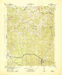 1942 Mineral1942 Print · USGSLouisa County during the early years of the war shows a landscape of rural crossroads and established rail hubs. Trace local history through family landmarks like Bibbs Store, Holladay Mill, and the many churches like Miners Chapel along the Chesapeake and Ohio line.2 unique versions available
 - 1942 Map of Pendleton, 1958 Print
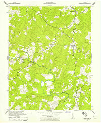 1942 Pendleton1958 Print · USGSLouisa County in the early 1940s was a landscape of small crossroads and river crossings. Genealogists and historians can trace the foundations of Yanceyville, locate the Chesapeake and Ohio tracks at Pendleton, and find rural landmarks like Goodwins Store.
 - 1943 Map of Pendleton
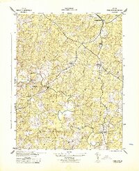 1943 Pendleton1943 Print · USGSLouisa County’s rural landscape is captured here during the Second World War, showing the agricultural heart of the Virginia Piedmont. Researchers can trace historic church sites like Gilboa Church and Yanceyville Church or locate landmarks like Goodwins Store and Smiths Mill.
 - 1943 Map of Richmond, 1972 Print
 1943 Richmond1972 Print · USGSCoastal Virginia and the state capital are shown in detail during the mid-century era of infrastructure expansion. Genealogists and historians can trace the grounds of Richmond Nat Battlefield Park, locate the Yorktown Nat Cem, or follow the many rural routes through Amelia Court House and Tappahannock.
 - 1948 Map of Washington
 1948 Washington1948 Print · USGSThe Potomac and Chesapeake regions in the late 1940s reveal a landscape of expanding military reach and deep-rooted Tidewater settlements. Trace old rail corridors like the Richmond Fredericksburg & Potomac RR or locate landmarks like the Wakefield Washington Monument and St. Marys College.2 unique versions available
 - 1949 Map of Richmond, 1951 Print
 1949 Richmond1951 Print · USGSCoastal Virginia in the years following World War II remained a landscape of historic river towns and expanding military bases. Genealogists and historians can trace the rail lines of the Southern Ry and locate established landmarks from Camp Lee to the remote reaches of Dragon Swamp.
End of results
Showing maps 1-6 of 6
Top cities near Mineral
Frequently asked questions
- What are the different types of historical maps available for Mineral?
- What is the oldest map of Mineral?
- Where can I purchase historical maps of Mineral for my home or office?
- Where can I download high-res historical maps of Mineral?
- Are there historical topographic maps available for Mineral?
- Is there historical aerial imagery available for Mineral?
- Where are historical maps of Mineral sourced from?