
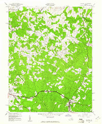
1942 Map of Mineral
USGS Topo · Published 1942About this map
Mineral and Louisa anchor this wartime landscape in the heart of Virginia, where the Chesapeake and Ohio railroad cuts a steady path through the terrain. The map captures a transition from town life to the rural crossroads of Ellisville and Wares Cross Roads. Local commerce and community life are clearly mapped through family-named landmarks like Bibbs Store, Dickinsons Store, and Holladay Mill.
Find a feature on this map
29 named features on this map. Tap any name to fly to it.
Don’t see what you’re looking for? This feature index may not catch every label — zoom into the map to look around manually.
Map Details
Editions of this 1942 Mineral Map
2 editions found
Other maps of this area

1887 · Spottsylvania
USGS Topo · 1:125,000

1890 · Goochland
USGS Topo · 1:125,000

1891 · Palmyra
USGS Topo · 1:125,000

1892 · Spottsylvania
USGS Topo · 1:125,000

1892 · Goochland
USGS Topo · 1:125,000

1892 · Gordonsville
USGS Topo · 1:125,000

1895 · Palmyra
USGS Topo · 1:125,000

1897 · Palmyra
USGS Topo · 1:125,000

1942 · Lahore
USGS Topo · 1:31,680

1942 · Belmont
USGS Topo · 1:31,680