1970s Maps of Whitlock, Virginia
Explore 2 historic maps of Whitlock from the 1970s. These maps offer a rare glimpse into what life looked like during the 1970s — showing old roads, neighborhoods, homes, and landmarks that have changed or disappeared over time.
Whether you're researching your family's past, planning a metal detecting trip, or studying how Whitlock's landscape evolved across the 1970s, these high-resolution maps are a powerful tool for exploring the history of this region.
- Focus on a specific era: All maps on this page are from the 1970s, giving you a focused view of this time period.
- See what’s changed: Compare century-old streets, trails, and buildings to today's modern landscape using overlays and satellite layers.
- Research with precision: Use these maps for genealogy, historical research, land use analysis, or educational projects.
- View, download, or print: Maps are fully viewable online in high resolution, and can be downloaded or printed for your own records.
Start exploring Whitlock's history through authentic maps from the 1970s. This is your window into the past.
Whitlock, VA maps
(2)- 1970 Map of Boswells Tavern, 1972 Print
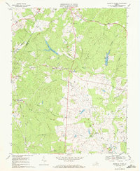 1970 Boswells Tavern1972 Print · USGSLouisa and Albemarle counties are captured in the early seventies as traditional rural communities evolved alongside the South Anna River. Researchers can locate established landmarks like Boswells Tavern, the Green Springs Sch, and Pleasant Plain Ch.4 unique versions available
 - 1977 Map of Boswells Tavern, 1982 Print
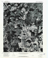 1977 Boswells Tavern1982 Print · USGSLouisa County in the late seventies is revealed through this aerial survey, showing the land's transition between forest and farm. Genealogists and local historians can trace the rural layouts of Boswells Tavern, Waldrop, and Meltons.
End of results
Showing maps 1-2 of 2
Top cities near Whitlock
- Lake Monticello historical maps
- Hollymead historical maps
- Pantops historical maps
- Orange historical maps
- Rivanna historical maps
- Piney Mountain historical maps
See more
Frequently asked questions
- What are the different types of historical maps available for Whitlock?
- What is the oldest map of Whitlock?
- Where can I purchase historical maps of Whitlock for my home or office?
- Where can I download high-res historical maps of Whitlock?
- Are there historical topographic maps available for Whitlock?
- Is there historical aerial imagery available for Whitlock?
- Where are historical maps of Whitlock sourced from?